Chardown Hill
| Chardown Hill | |
|---|---|
 Chardown Hill | |
| Highest point | |
| Elevation | 194 m (636 ft)[1][2] |
| Prominence | 68 m (223 ft)[1] |
| Parent peak | Hardown Hill[1] |
| Listing | Tump |
| Coordinates | 50°44′23″N 2°51′22″W / 50.73972°N 2.85611°W |
| Geography | |
| Location | Dorset, England |
| Parent range | South Dorset Downs |
| OS grid | SY396936 |
| Topo map | OS Landranger 193 |
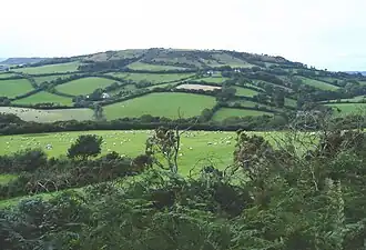
Chardown Hill is a prominent, rounded hill, 194 metres (636 ft) high,[1] just to the southwest of the village of Morcombelake in the county of Dorset in southern England. It overlooks the Dorset coast around 1½ kilometres to the south.[2] Its prominence of 63 metres (207 ft) means it is listed as one of the Tumps.[1] It is located within the South Dorset Downs.
The summit area is open and crossed by a bridleway running roughly north to south. Just south of the actual summit it is joined by a public footpath approaching from Stonebarrow Hill, the western spur of Chardown. The South West Coast Path passed along the foot of Chardown Hill and above the coastal cliffs.[2]