Chian Yai district
Chian Yai
เชียรใหญ่ | |
|---|---|
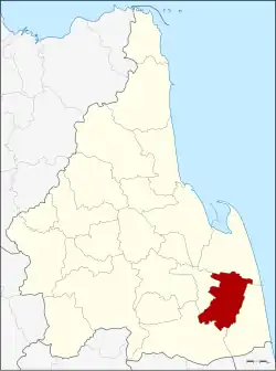 District location in Nakhon Si Thammarat province | |
| Coordinates: 8°10′6″N 100°8′42″E / 8.16833°N 100.14500°E | |
| Country | Thailand |
| Province | Nakhon Si Thammarat |
| Seat | Chian Yai |
| Area | |
• Total | 232.7 km2 (89.8 sq mi) |
| Population (2005) | |
• Total | 45,827 |
| • Density | 196.9/km2 (510/sq mi) |
| Time zone | UTC+7 (ICT) |
| Postal code | 80190 |
| Geocode | 8006 |
Chian Yai (Thai: เชียรใหญ่, pronounced [t͡ɕʰīa̯n jàj]) is a district (amphoe) in the southeastern part of Nakhon Si Thammarat province, southern Thailand.
Geography
Neighboring districts are (from the north clockwise): Pak Phanang, Hua Sai, Cha-uat, and Chaloem Phra Kiat.
History
The minor district (king amphoe) on 1 February 1937 by splitting it from Pak Phanang district. It was upgraded to a full district on 3 November 1947.
Administration
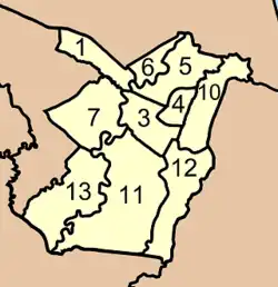
The district is divided into 10 sub-districts (tambons), which are further subdivided into 98 villages (mubans). Chian Yai is a township (thesaban tambon) which covers parts of tambons Chian Yai, Tha Khanan, and Thong Lamchiak. There are a further nine tambon administrative organizations (TAO).
|
|
Missing numbers belong to tambons which now form Chaloem Phra Kiat.