Chilgok County
Chilgok
칠곡군 | |
|---|---|
| Korean transcription(s) | |
| • Hangul | 칠곡군 |
| • Hanja | 漆谷郡 |
| • Revised Romanization | Chilgok-gun |
| • McCune-Reischauer | Ch'ilgok-kun |
 Flag Emblem of Chilgok | |
 Location in South Korea | |
| Country | |
| Region | Yeongnam |
| Administrative divisions | 3 eup, 5 myeon |
| Area | |
• Total | 451 km2 (174 sq mi) |
| Population | |
• Total | 107,158 |
| • Density | 237.6/km2 (615/sq mi) |
| • Dialect | Gyeongsang |
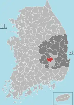
Chilgok County (Chilgok-gun) is in southwest North Gyeongsang Province, South Korea. It is near Gunwi County to the east and adjoins Gimchon-si, Seongju County to the west. It is on the Nakdong river.
Geography and climate
Its geographical coordinate is 128°18'-128°38'to the east longitude and the north latitude 35°52' - 36°38' with average temperature of 14.8 °C and 948mm amount of rainfall.
Administrative divisions
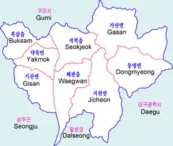
Chilgok County is divided into 3 eup and 5 myeon.
| Name | Hangeul | Hanja |
|---|---|---|
| Waegwan-eup | 왜관읍 | 倭館邑 |
| Buksam-eup | 북삼읍 | 北三邑 |
| Seokjeok-eup | 석적읍 | 石積邑 |
| Jicheon-myeon | 지천면 | 枝川面 |
| Dongmyeong-myeon | 동명면 | 東明面 |
| Gasan-myeon | 가산면 | 架山面 |
| Yakmok-myeon | 약목면 | 若木面 |
| Gisan-myeon | 기산면 | 岐山面 |
References
Wikimedia Commons has media related to Chilgok.
External links
- County government website Archived 2016-09-24 at the Wayback Machine
- Cheonsaengsanseong Fortresss
- Gasansanseong Fortress
Andong (capital) | ||||
 | Specific city |
| ||
| Cities | ||||
| Counties | ||||