Chocholná-Velčice
Chocholná-Velčice | |
|---|---|
 Flag | |
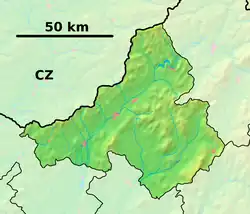 Chocholná-Velčice Location of Chocholná-Velčice in the Trenčín Region  Chocholná-Velčice Location of Chocholná-Velčice in Slovakia | |
| Coordinates: 48°52′N 17°56′E / 48.87°N 17.94°E | |
| Country | |
| Region | |
| District | Trenčín District |
| First mentioned | 1345 |
| Area | |
• Total | 27.90 km2 (10.77 sq mi) |
| Elevation | 371 m (1,217 ft) |
| Population (2021)[3] | |
• Total | 1,671 |
| Time zone | UTC+1 (CET) |
| • Summer (DST) | UTC+2 (CEST) |
| Postal code | 913 04[2] |
| Area code | +421 32[2] |
| Car plate | TN |
| Website | www |
Chocholná-Velčice (Hungarian: Tarajosvelcsőc) is a village and municipality in Trenčín District in the Trenčín Region of north-western Slovakia.
History
In historical records the village was first mentioned in 1345.
Geography
The municipality lies at an altitude of 227 metres and covers an area of 27.898 km². It has a population of about 1695 people.
Genealogical resources
The records for genealogical research are available at the state archive "Statny Archiv in Bratislava, Slovakia"
- Roman Catholic church records (births/marriages/deaths): 1714-1896 (parish B)
See also
References
- ^ "Hustota obyvateľstva - obce [om7014rr_ukaz: Rozloha (Štvorcový meter)]". www.statistics.sk (in Slovak). Statistical Office of the Slovak Republic. 2022-03-31. Retrieved 2022-03-31.
- ^ a b c "Základná charakteristika". www.statistics.sk (in Slovak). Statistical Office of the Slovak Republic. 2015-04-17. Retrieved 2022-03-31.
- ^ "Počet obyvateľov podľa pohlavia - obce (ročne)". www.statistics.sk (in Slovak). Statistical Office of the Slovak Republic. 2022-03-31. Retrieved 2022-03-31.