Clay Butte Lookout
Clay Butte Lookout | |
 | |
  | |
| Location | Approx. 1/2 mi. N. of jct. of US 212 and FS Rd. 142, Park County, Wyoming |
|---|---|
| Nearest city | Clark, Wyoming |
| Coordinates | 44°56′40″N 109°37′36″W / 44.944392°N 109.626573°W |
| Area | 2.5 acres (1.0 ha) |
| Built | 1941-1943 |
| NRHP reference No. | 13001065[1] |
| Added to NRHP | January 8, 2014 |
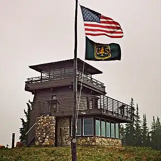
The Clay Butte Lookout is a forest fire lookout in Park County, Wyoming. It was listed on the National Register of Historic Places in 2014.[1]
It is located in the northern Absaroka Range in the Shoshone National Forest about sixteen miles east of Yellowstone National Park and about four miles south of the Wyoming-Montana state border. It is about one half mile north of U.S. Highway 212, at the end of FS Rd. 142 which winds up to it.[2]
Its construction was started in 1941 within the Civilian Conservation Corps program, but the CCC was closed before it was completed in 1943. It is a three-story wood-sided structure built out of eight inch by eight inch beams. It is 26.25 feet (8.00 m) tall.[2]
It is near Clark, Wyoming.
References
- ^ a b NP Gallery: 13001065
- ^ a b Elizabeth L. and Robert G. Rosenberg (August 2013). "National Register of Historic Places Registration: Clay Butte Lookout / Clay Butte Tower; Clay Butte Fire Lookout; Site 48PA2492" (PDF). National Park Service. Archived from the original (PDF) on February 2, 2017. Retrieved April 27, 2017.
Wikimedia Commons has media related to Clay Butte Lookout.