Clay Township, Bartholomew County, Indiana
Clay Township | |
|---|---|
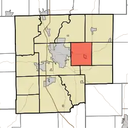 Location in Bartholomew County | |
| Coordinates: 39°13′26″N 85°49′02″W / 39.22389°N 85.81722°W | |
| Country | United States |
| State | Indiana |
| County | Bartholomew |
| Government | |
| • Type | Indiana township |
| Area | |
• Total | 23.16 sq mi (60.0 km2) |
| • Land | 23.15 sq mi (60.0 km2) |
| • Water | 0.01 sq mi (0.03 km2) 0.04% |
| Elevation | 640 ft (195 m) |
| Population | |
• Total | 3,145 |
| • Density | 141.3/sq mi (54.6/km2) |
| ZIP codes | 47201, 47203, 47246 |
| GNIS feature ID | 0453204 |
Clay Township is one of twelve townships in Bartholomew County, Indiana, United States. As of the 2010 census, its population was 3,271 and it contained 1,320 housing units.[2]
Geography
According to the 2010 census, the township has a total area of 23.16 square miles (60.0 km2), of which 23.15 square miles (60.0 km2) (or 99.96%) is land and 0.01 square miles (0.026 km2) (or 0.04%) is water.[2]
Cities, towns, villages
- Columbus (east edge)
Unincorporated towns
This list is based on USGS data and may include former settlements.
Adjacent townships
- Haw Creek Township (northeast)
- Clifty Township (east)
- Rock Creek Township (southeast)
- Columbus Township (west)
- Flat Rock Township (northwest)
Cemeteries
The township contains these two cemeteries: Sand Hill and Sharon.
Major highways
Landmarks
- Otter Creek County Golf Course
School districts
- Bartholomew Consolidated School Corporation
Political districts
- Indiana's 6th congressional district
- State House District 57
- State Senate District 41
References
Citations
- ^ "Census Bureau profile: Clay Township, Bartholomew County, Indiana". United States Census Bureau. May 2023. Retrieved March 23, 2024.
- ^ a b "Population, Housing Units, Area, and Density: 2010 - County -- County Subdivision and Place -- 2010 Census Summary File 1". United States Census. Archived from the original on February 12, 2020. Retrieved May 10, 2013.
Sources
- United States Census Bureau 2007 TIGER/Line Shapefiles
- United States Board on Geographic Names (GNIS)
- United States National Atlas
External links
Wikimedia Commons has media related to Clay Township, Bartholomew County, Indiana.
Municipalities and communities of Bartholomew County, Indiana, United States | ||
|---|---|---|
| City | 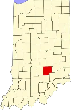 | |
| Towns | ||
| Townships | ||
| CDPs | ||
| Other communities | ||
| Ghost town | ||
| Footnotes | ‡This populated place also has portions in an adjacent county or counties | |