Cleveland, New Mexico
Cleveland, New Mexico | |
|---|---|
 Cleveland  Cleveland | |
| Coordinates: 35°59′36″N 105°22′14″W / 35.99333°N 105.37056°W | |
| Country | United States |
| State | New Mexico |
| County | Mora |
| Elevation | 7,375 ft (2,248 m) |
| Time zone | UTC-7 (Mountain (MST)) |
| • Summer (DST) | UTC-6 (MDT) |
| ZIP codes | 87715[1] |
| Area code | 505 |
| GNIS feature ID | 915813[2] |
Cleveland is an unincorporated community located in Mora County, New Mexico, United States. The community is located on New Mexico State Road 518, 2.6 miles (4.2 km) west-northwest of Mora. Cleveland has a post office with ZIP code 87715, which opened on August 11, 1892.[1][3] The town was named after President Grover Cleveland.[4]
References
- ^ a b United States Postal Service. "USPS - Look Up a ZIP Code". Retrieved November 28, 2014.
- ^ "Cleveland". Geographic Names Information System. United States Geological Survey, United States Department of the Interior.
- ^ "Postmaster Finder - Post Offices by ZIP Code". United States Postal Service. Archived from the original on October 17, 2020. Retrieved November 29, 2014.
- ^ Julyan, Robert (1996). The Place Names of New Mexico. University of New Mexico Press. p. 88. ISBN 0826316891.
Municipalities and communities of Mora County, New Mexico, United States | ||
|---|---|---|
| Village | 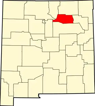 | |
| CDPs | ||
| Other communities | ||