Lissoughter
| Lissoughter | |
|---|---|
| Cnoc Lios Uachtair | |
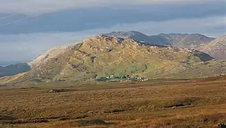 Lissoughter from the southwest; the tallest peak behind it is Binn idir an da Log | |
| Highest point | |
| Elevation | 401 m (1,316 ft)[1] |
| Prominence | 336 m (1,102 ft)[1] |
| Listing | Marilyn |
| Coordinates | 53°29′01″N 9°43′07″W / 53.48358°N 9.718475°W[1] |
| Naming | |
| English translation | hill of the upper ringfort |
| Language of name | Irish |
| Geography | |
 Lissoughter Location in Ireland | |
| Location | Recess, County Galway, Ireland |
| Parent range | Twelve Bens-Maumturks |
| OSI/OSNI grid | L8596849524 |
| Topo map | OSi Discovery 44 |
| Geology | |
| Rock type(s) | Pale quartzites, grits, graphitic top bedrock[1] |
Lissoughter or Lissoughter Hill (Irish: Cnoc Lios Uachtair, meaning 'hill of the upper ring-fort')[2] is a prominent hill between the Twelve Bens and Maumturks mountain ranges, at the southern entrance to the Inagh Valley, in the Connemara National Park of County Galway, Ireland.[3][4] With a height of 401 metres (1,316 ft), it does not qualify to be an Arderin or a Vandeleur-Lynam, however, its prominence of 336 metres (1,102 ft) ranks it as a Marilyn.[5][6][3]
A quarry on Lissoughter's southern slopes (the Lissoughter-Derryclare quarry, named after the peak and the neighbouring Derryclare mountain), is a noted source of the green-coloured Connemara marble (sometimes called Connemara Lissoughter Marble).[2][7][8] As an isolated standalone peak, it is less frequented by hill-walkers, however, it is regarded for its views of the two ranges and the southern boglands of Connemara.[4][7]
Gallery
-
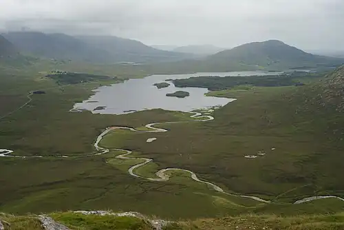 Lough Inagh and Lissoughter (back, right), viewed from Knockpasheemore
 -
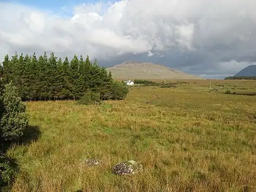 Lissoughter, viewed from forest in Recess, County Galway
 -
 Connemara marble from the Lissoughter quarry.
Bibliography
- MountainViews Online Database (Simon Stewart) (2013). A Guide to Ireland's Mountain Summits: The Vandeleur-Lynams & the Arderins. Collins Books. ISBN 978-1-84889-164-7.
- Tim Robinson (2007). Connemara: Listening to the Wind. Penguin. ISBN 978-1844880669.
- Dillion, Paddy (2001). Connemara: Collins Rambler's guide. Harper Collins. ISBN 978-0002201216.
- Dillion, Paddy (1993). The Mountains of Ireland: A Guide to Walking the Summits. Cicerone. ISBN 978-1852841102.
See also
- Twelve Bens, major range in Connemara
- Maumturks, major range in Connemara
- List of Marilyns in the British Isles
References
- ^ a b c d "Lissoughter". MountainViews Online Database. Retrieved 13 August 2019.
- ^ a b Paul Tempan (February 2012). "Irish Hill and Mountain Names" (PDF). MountainViews.ie.
- ^ a b Mountainviews, (September 2013), "A Guide to Ireland's Mountain Summits: The Vandeleur-Lynams & the Arderins", Collins Books, Cork, ISBN 978-1-84889-164-7
- ^ a b Dillion, Paddy (2001). Connemara: Collins Rambler's guide. Harper Collins. ISBN 978-0002201216.
Walk 20: Recess and Cnoc Lios Uachtair
- ^ Simon Stewart (October 2018). "Arderins: Irish mountains of 500+m with a prominence of 30m". MountainViews Online Database.
- ^ Simon Stewart (October 2018). "Vandeleur-Lynams: Irish mountains of 600+m with a prominence of 15m". MountainViews Online Database.
- ^ a b Tim Robinson (2007). Connemara: Listening to the Wind. Penguin. ISBN 978-1844880669.
- ^ "CONNEMARBLE GREEN Irish marble". MarbleGuide.com. Retrieved 13 August 2019.
Connemarble Green is a green marble from Ireland (Derryclare, Lissoughter, Recess, Co. Galway, Connemara).
External links
- MountainViews: The Irish Mountain Website, Lissoughter
- MountainViews: Irish Online Mountain Database
- The Database of British and Irish Hills , the largest database of British Isles mountains ("DoBIH")
- Hill Bagging UK & Ireland, the searchable interface for the DoBIH
| British Isles |  | |
|---|---|---|
| Scotland | ||
| Outside Scotland | ||
| England | ||
| Ireland | ||
| County tops | ||
Mountains and hills of Connacht | |||||||
|---|---|---|---|---|---|---|---|
| Achill Island | 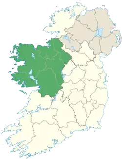 | ||||||
| Dartry Mountains | |||||||
| Maumturks | |||||||
| Mweelrea Mountains | |||||||
| Nephin Range | |||||||
| Ox Mountains | |||||||
| Partry Mountains | |||||||
| Sheeffry Range | |||||||
| Benna Beola |
| ||||||
| Others | |||||||
.jpg)
