Conflict Group
 Satellite image | |
 | |
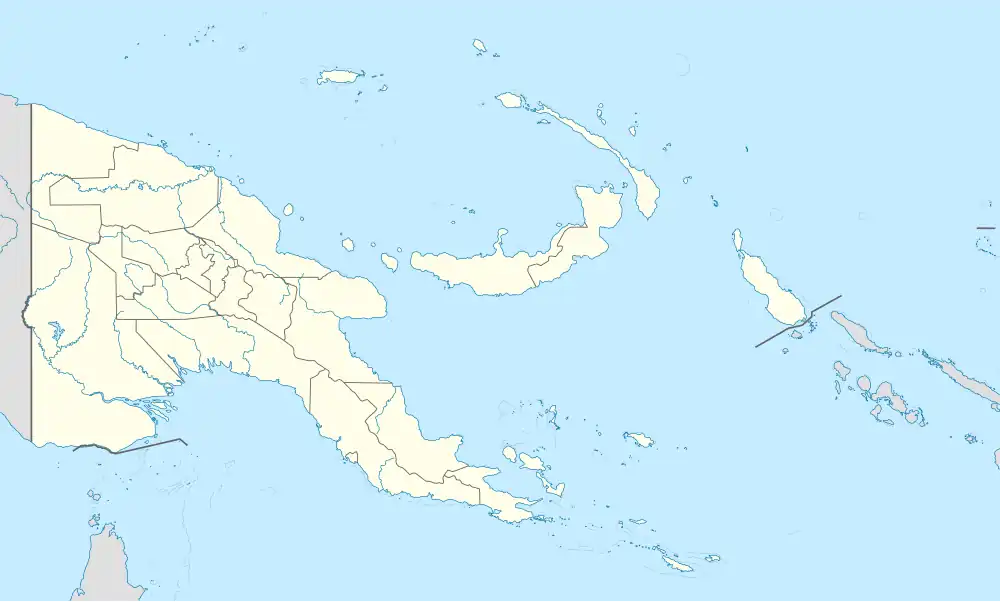 Conflict Islands Location of the Conflict Islands | |
| Geography | |
|---|---|
| Location | Oceania |
| Coordinates | 10°46′48″S 151°47′32″E / 10.78000°S 151.79222°E[1] |
| Archipelago | Louisiade Archipelago |
| Adjacent to | Solomon Sea |
| Total islands | 21 |
| Major islands | |
| Area | 4.55 km2 (1.76 sq mi) |
| Length | 21 km (13 mi) |
| Width | 10 km (6 mi) |
| Administration | |
| Province | |
| District | Samarai-Murua District |
| LLG[2] | Bwanabwana Rural LLG |
| Island Group | Calvados Chain |
| Largest settlement | Irai (pop. 20) |
| Demographics | |
| Population | 30 (2014) |
| Pop. density | 6.6/km2 (17.1/sq mi) |
| Ethnic groups | Papauans, Austronesians, Melanesians. |
| Additional information | |
| Time zone | |
| ISO code | PG-MBA |
| Official website | www |
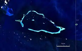
The Conflict Group is an atoll in Papua New Guinea. The group was sighted in 1879 by HMS Cormorant, by moonlight; it was named in 1880 by Bower, captain of HMS Conflict.[3] Irai Island is the center of population of the group.
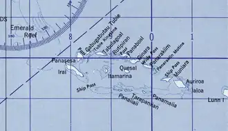
The small Panasesa Island has an eco resort with a small staff.
In September 2022 the Papua New Guinea government ordered an investigation into the islands' ownership after their owner, Australian businessman Ian Gowrie Smith, attempted to sell them.[4]
Islands in Conflict Group
The individual islands in a clockwise direction, starting in the west (Kisa and Itamarina in the lagoon):
Differing surface areas, and sometimes divergent names for individual islands can be found in Oceandots: Irai (97 ha; 240 acres), Panasesa (63.5 ha; 157 acres), Auriora (61 ha; 150 acres), Panarakum (38.8 ha; 96 acres), Panibari (24.7 ha; 61 acres), Tubiniguam (17.8 ha; 44 acres), Moniara (13 ha; 32 acres), Ginouri (11 ha; 27 acres) and Tupit (10 ha; 25 acres). Thereafter, the total land area of the archipelago is 3.75 km2 (1.45 sq mi).[5]
References
- ^ Prostar Sailing Directions 2004 New Guinea Enroute, p. 168
- ^ Selve B, Bwaduai S, Nisa M, James K, Usurup JP, Turner P, Melrose W, Yas W, Samuel R, Eddie C (2000). "Community empowerment in the control of lymphatic filariasis in Misima, Milne Bay Province using diethylcarbamazine in combination with albendazole" (PDF). The Papua New Guinea Medical Journal. 43 (3-4 Sep-Dec): 184. Archived from the original (PDF) on 11 August 2010.
- ^ Arthur Wichman (Hrsg.): History of New-Guinea (bis 1828). Bd. 1, E. J. Brill, Leiden 1909, S. 271
- ^ "Investigation into Conflict Islands". Papua New Guinea Post-Courier. 1 September 2022. Retrieved 1 September 2022.
- ^ Oceandots.com: Conflict Islands
Islands of Papua New Guinea | |
|---|---|
| Bismarck Archipelago | |
| Louisiade Archipelago | |
| North Solomon Islands | |