Counties of Liberia
| Counties of Liberia | |
|---|---|
 | |
| Category | Unitary state |
| Location | Republic of Liberia |
| Number | 15 counties |
| Populations | 90,777 (Rivercess) – 1,920,914 (Montserrado) |
| Areas | 4,020 km2 (1,553 sq mi) (Montserrado) – 11,600 km2 (4,460 sq mi) (Nimba) |
| Government |
|
| Subdivisions | |
 |
|---|
|
|
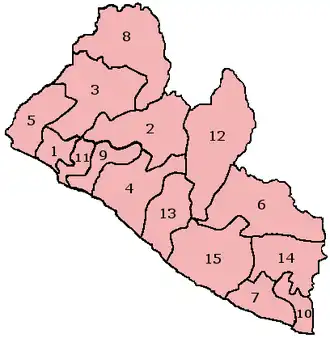
The Republic of Liberia is divided into fifteen counties. Each is administered by a superintendent appointed by the President.
Counties
| Map # | County | Capital | Population (2022 Census)[1] |
Area (mi2)[2] |
Number of Districts |
Date Created |
Parent County |
|---|---|---|---|---|---|---|---|
| 1 | Tubmanburg | 133,668 | 749 sq mi (1,940 km2) | 4 | 1984 | Montserrado County | |
| 2 | Gbarnga | 467,502 | 3,386 sq mi (8,770 km2) | 12 | 1964 | Bong County[a] | |
| 3 | Bopolu | 95,995 | 3,740 sq mi (9,700 km2) | 6 | 2001 | Lofa County | |
| 4 | Buchanan | 293,557 | 3,064 sq mi (7,940 km2) | 8 | 1839 | Grand Bassa County[b] | |
| 5 | Robertsport | 178,798 | 1,993 sq mi (5,160 km2) | 5 | 1844 | Grand Cape Mount County[b] | |
| 6 | Zwedru | 216,692 | 4,047 sq mi (10,480 km2) | 3 | 1964 | Grand Gedah County[c] | |
| 7 | Barclayville | 109,342 | 1,503 sq mi (3,890 km2) | 18 | 1984 | Maryland County | |
| 8 | Voinjama | 367,376 | 3,854 sq mi (9,980 km2) | 6 | 1964 | Lofa County[d] | |
| 9 | Kakata | 304,946 | 1,010 sq mi (2,600 km2) | 4 | 1985 | Montserrado County | |
| 10 | Harper | 172,202 | 886 sq mi (2,290 km2) | 2 | 1857 | Maryland County[b] | |
| 11 | Bensonville | 1,920,914 | 737 sq mi (1,910 km2) | 17 | 1839 | Montserrado County[b] | |
| 12 | Sanniquellie | 621,841 | 4,459 sq mi (11,550 km2) | 6 | 1964 | Nimba County[a] | |
| 13 | River Cess | 90,777 | 2,159 sq mi (5,590 km2) | 7 | 1985 | Grand Bassa County | |
| 14 | Fish Town | 124,653 | 1,974 sq mi (5,110 km2) | 6 | 2000 | Grand Gedah County | |
| 15 | Greenville | 150,358 | 3,913 sq mi (10,130 km2) | 17 | 1843 | Simoe County[b] |
- Notes
See also
- List of Liberian counties by Human Development Index
- Administrative divisions of Liberia
- ISO 3166-2:LR
References
- ^ "Liberia: Counties, Major Cities, Towns & Urban Areas - Population Statistics, Maps, Charts, Weather and Web Information". www.citypopulation.de. Retrieved 2024-01-16.
- ^ "2008 National Population and Housing Census: Preliminary Results" (PDF). Government of the Republic of Liberia. 2008. Archived from the original (PDF) on February 13, 2012. Retrieved October 14, 2008.
External links
- "Counties of Liberia". Statoids.
- Official Liberian Census Final Results 2008 Archived 2013-09-11 at the Wayback Machine