Cubières
Cubières | |
|---|---|
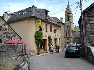 A view within the village, of the church and surrounding buildings | |
.svg.png) Coat of arms | |
Location of Cubières | |
 Cubières  Cubières | |
| Coordinates: 44°28′27″N 3°46′24″E / 44.4742°N 3.7733°E | |
| Country | France |
| Region | Occitania |
| Department | Lozère |
| Arrondissement | Mende |
| Canton | Saint-Étienne-du-Valdonnez |
| Intercommunality | CC Mont Lozère |
| Government | |
| • Mayor (2020–2026) | Stéphan Massador[1] |
Area 1 | 48.88 km2 (18.87 sq mi) |
| Population (2022)[2] | 189 |
| • Density | 3.9/km2 (10/sq mi) |
| Time zone | UTC+01:00 (CET) |
| • Summer (DST) | UTC+02:00 (CEST) |
| INSEE/Postal code | 48053 /48190 |
| Elevation | 756–1,633 m (2,480–5,358 ft) (avg. 900 m or 3,000 ft) |
| 1 French Land Register data, which excludes lakes, ponds, glaciers > 1 km2 (0.386 sq mi or 247 acres) and river estuaries. | |
Cubières (French pronunciation: [kybjɛʁ]; Occitan: Cubièira) is a commune in the Lozère department in southern France.[3]
See also
References
- ^ "Répertoire national des élus: les maires" (in French). data.gouv.fr, Plateforme ouverte des données publiques françaises. 13 September 2022.
- ^ "Populations de référence 2022" (in French). The National Institute of Statistics and Economic Studies. 19 December 2024.
- ^ INSEE commune file
Wikimedia Commons has media related to Cubières.