Cucumber Run (Youghiogheny River tributary)
| Cucumber Run Tributary to Youghiogheny River | |
|---|---|
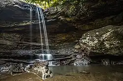 Cucumber Falls on Cucumber Run | |
 Location of Cucumber Run mouth  Cucumber Run (Youghiogheny River tributary) (the United States) | |
| Location | |
| Country | United States |
| State | Pennsylvania |
| County | Fayette |
| Physical characteristics | |
| Source | Meadow Run divide |
| • location | about 2 miles south of Deer Lake, Pennsylvania[2] |
| • coordinates | 39°50′21″N 079°32′55″W / 39.83917°N 79.54861°W[1] |
| • elevation | 1,895 ft (578 m)[2] |
| Mouth | Youghiogheny River |
• location | about 0.25 miles southesst of Ohiopyle, Pennsylvania[3] |
• coordinates | 39°51′50″N 079°30′04″W / 39.86389°N 79.50111°W[1] |
• elevation | 1,042 ft (318 m)[3] |
| Length | 3.09 mi (4.97 km)[4] |
| Basin size | 6.42 square miles (16.6 km2)[5] |
| Discharge | |
| • location | Youghiogheny River |
| • average | 14.50 cu ft/s (0.411 m3/s) at mouth with Youghiogheny River[5] |
| Basin features | |
| Progression | Youghiogheny River → Monongahela River → Ohio River → Mississippi River → Gulf of Mexico |
| River system | Monongahela River |
| Tributaries | |
| • left | North Branch Cucumber Run |
| • right | unnamed tributaries |
| Bridges | Bell Grove Road, Middle Ridge Road, Ohiopyle Road |
Cucumber Run is a 3.09 mi (4.97 km) long 3rd order tributary to the Youghiogheny River in Fayette County, Pennsylvania.
Course
Cucumber Run rises about 2 miles southeast of Deer Lake, Pennsylvania,[2] and then flows northeast to join the Youghiogheny River about 0.25 miles southeast of Ohiopyle.[3]
Watershed
Cucumber Run drains 6.42 square miles (16.6 km2) of area, receives about 51.1 in/year of precipitation, has a wetness index of 350.68, and is about 85% forested.[5]
See also
References
- ^ a b "GNIS Detail - Cucumber Run". geonames.usgs.gov. US Geological Survey. Retrieved 24 November 2020.
- ^ a b c "Get Maps". USGS Topoview. US Geological Survey. Retrieved 24 November 2020.
- ^ a b c "Get Maps". USGS Topoview. US Geological Survey. Retrieved 24 November 2020.
- ^ "ArcGIS Web Application". epa.maps.arcgis.com. US EPA. Retrieved 24 November 2020.
- ^ a b c "Cucumber Run Watershed Report". US EPA Geoviewer. US EPA. Retrieved 24 November 2020.