Dobra, Łobez County
Dobra | |
|---|---|
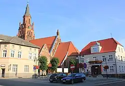 Town center with the Saint Clare church and the town hall | |
_COA.svg.png) Coat of arms | |
 Dobra | |
| Coordinates: 53°35′0″N 15°18′20″E / 53.58333°N 15.30556°E | |
| Country | |
| Voivodeship | West Pomeranian |
| County | Łobez |
| Gmina | Dobra |
| Town rights | before 1331 |
| Government | |
| • Mayor | Krzysztof Wrzesień |
| Area | |
• Total | 2.32 km2 (0.90 sq mi) |
| Highest elevation | 92 m (302 ft) |
| Lowest elevation | 72 m (236 ft) |
| Population (31 December 2021[1]) | |
• Total | 2,215 |
| • Density | 950/km2 (2,500/sq mi) |
| Time zone | UTC+1 (CET) |
| • Summer (DST) | UTC+2 (CEST) |
| Postal code | 72-210 |
| Area code | +48 91 |
| Vehicle registration | ZLO |
| Voivodeship roads | |
| Website | http://www.dobragmina.pl |
Dobra [ˈdɔbra] (German: Daber), also known as Dobra Nowogardzka, is a town in Łobez County, West Pomeranian Voivodeship, in northwestern Poland,[2] with 2,215 inhabitants as of December 2021.[1]
History

In the Middle Ages a Slavic gród existed in present-day Dobra.[3] The territory became part of the emerging Polish state under its first ruler Mieszko I around 967.[4] It was granted town rights before 1331.[5] The region became part of the Holy Roman Empire of the German NAtion. In the 13th and 14th centuries a castle was built, rebuilt later in the 16th century,[3] and heavily damaged in the 17th to 19th centuries. In 1647, due to the plague epidemic, the population of Dobra fell from over 600 to 48 people.[3] From the 18th century, it was part of Prussia, and stayed part of Germany until 1945. In 1895, a narrow-gauge railway was built, connecting the town with Stargard.[3] Following the defeat of Nazi Germany in World War II it became part of Poland.
Demographics
|
| |||||||||||||||||||||||||||||||||
| Source: [6][7] | ||||||||||||||||||||||||||||||||||
Gallery
-
![The oldest preserved townhouse in Dobra[3]](./_assets_/Dobra%252C_dom_-_1.JPG) The oldest preserved townhouse in Dobra[3]
The oldest preserved townhouse in Dobra[3] -
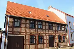 Old timber framed house
 -
 Saint Clare church
 -
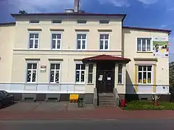 Library
References
- ^ a b "Local Data Bank". Statistics Poland. Retrieved 2022-07-30. Data for territorial unit 3218014.
- ^ "Główny Urząd Statystyczny" [Central Statistical Office] (in Polish). To search: Select "Miejscowości (SIMC)" tab, select "fragment (min. 3 znaki)" (minimum 3 characters), enter town name in the field below, click "WYSZUKAJ" (Search).
- ^ a b c d e "Historia Dobrej, Gmina Dobra" (in Polish). Retrieved July 17, 2019.
- ^ Labuda, Gerard (1993). "Chrystianizacja Pomorza (X–XIII stulecie)". Studia Gdańskie (in Polish). Vol. IX. Gdańsk-Oliwa. p. 47.
- ^ Krzysztofik, Robert (2007). Lokacje miejskie na obszarze Polski. Dokumentacja geograficzno-historyczna (in Polish). Katowice: Wydawnictwo Uniwersytetu Śląskiego. pp. 28–29. ISBN 978-83-226-1616-1.
- ^ Dokumentacja Geograficzna (in Polish). Vol. 3/4. Warszawa: Instytut Geografii Polskiej Akademii Nauk. 1967. p. 10.
- ^ Stan i struktura ludności oraz ruch naturalny w przekroju terytorialnym w 2010 r. (PDF) (in Polish). Warszawa: Główny Urząd Statystyczny. 2011. p. 109. Archived from the original (PDF) on 13 November 2011.
External links
| Seat |  | |
|---|---|---|
| Urban-rural gminas | ||
| Rural gmina | ||
| Town and seat | | |
|---|---|---|
| Villages | ||