Dampierre-le-Château
Dampierre-le-Château | |
|---|---|
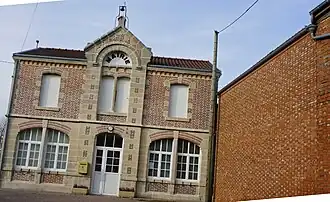 The town hall in Dampierre-le-Château | |
Location of Dampierre-le-Château | |
 Dampierre-le-Château  Dampierre-le-Château | |
| Coordinates: 49°00′37″N 4°47′47″E / 49.0103°N 4.7964°E | |
| Country | France |
| Region | Grand Est |
| Department | Marne |
| Arrondissement | Châlons-en-Champagne |
| Canton | Argonne Suippe et Vesle |
| Intercommunality | Argonne Champenoise |
| Government | |
| • Mayor (2020–2026) | Maxime Dausseur[1] |
Area 1 | 11.13 km2 (4.30 sq mi) |
| Population (2022)[2] | 117 |
| • Density | 11/km2 (27/sq mi) |
| Time zone | UTC+01:00 (CET) |
| • Summer (DST) | UTC+02:00 (CEST) |
| INSEE/Postal code | 51206 /51330 |
| Elevation | 175 m (574 ft) |
| 1 French Land Register data, which excludes lakes, ponds, glaciers > 1 km2 (0.386 sq mi or 247 acres) and river estuaries. | |
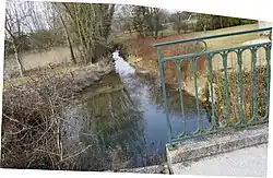
Dampierre-le-Château (French pronunciation: [dɑ̃pjɛʁləʃɑto]) is a commune of the Marne department in the Grand Est region of France. It is located on the Yèvre river.
History

Before the French Revolution, it was called "Dampierre-en-Astenois". It was renamed "Dampierre-sur-Yèvre" in 1793, and eventually "Dampierre-le-Château" in 1801.
See also
References
- ^ "Répertoire national des élus: les maires" (in French). data.gouv.fr, Plateforme ouverte des données publiques françaises. 13 September 2022.
- ^ "Populations de référence 2022" (in French). The National Institute of Statistics and Economic Studies. 19 December 2024.
Wikimedia Commons has media related to Dampierre-le-Château.