Dargaville Aerodrome
Dargaville Aerodrome | |||||||||||||||
|---|---|---|---|---|---|---|---|---|---|---|---|---|---|---|---|
 | |||||||||||||||
| Summary | |||||||||||||||
| Airport type | Public | ||||||||||||||
| Operator | Dargaville Aero Club | ||||||||||||||
| Location | Dargaville | ||||||||||||||
| Elevation AMSL | 6 ft / 1.9 m | ||||||||||||||
| Coordinates | 35°56′23″S 173°53′37″E / 35.93972°S 173.89361°E | ||||||||||||||
| Runways | |||||||||||||||
| |||||||||||||||
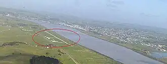
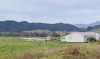
Dargaville Aerodrome (IATA: DGR, ICAO: NZDA)[1] is a small airport located 1 Nautical Mile (1.9 km) southeast of Dargaville township in Northland, New Zealand.
The airfield has an active aero club that provides training in advanced microlights, and has a regular 'fly-in' lunch every Saturday which attracts aviators from New Zealand's North island.
It is a base for topdressing aircraft working the surrounding area, and has Avgas available with a "Z" swipecard.
Other airfields near to Dargaville are Ruawai Aerodrome, Whangarei Airport, Waro Airstrip, Kaikohe Airport and Waitotehoanga Airstrip.[1]
Operational Information
- Airfield Elevation: 6 ft AMSL
- Runway 04/22 – 1000 x 12 metres rolled limestone
- Runway 04/22 – 931 x 11 metres grass
- Runway Strength – 02/20: ESWL 2500
- No runway lighting available
- Circuit:
- Runways 04 – Right Hand
- Runways 22 – Left Hand
Sources
- ^ a b "Dargaville Aerodrome". Metar & Taf.
- NZAIP Volume 4 AD
- New Zealand AIP (PDF)
- Dargaville Aero Club web site [1]