Dep (river)
| Dep | |
|---|---|
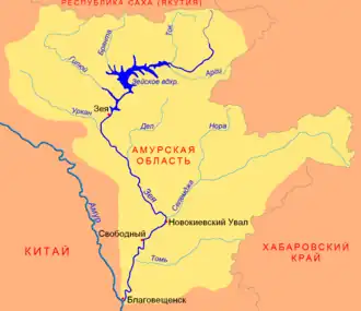 Zeya basin | |
 Mouth location in Amur Oblast, Russia | |
| Location | |
| Country | Russia |
| Physical characteristics | |
| Mouth | Zeya |
• coordinates | 52°52′16″N 127°44′47″E / 52.8711°N 127.7464°E |
| Length | 348 km (216 mi) |
| Basin size | 10,400 km2 (4,000 sq mi) |
| Basin features | |
| Progression | Zeya→ Amur→ Sea of Okhotsk |
The Dep (Russian: Деп) is a left tributary of the Zeya (itself a tributary of the Amur) in Amur Oblast, eastern Russia. It is 348 kilometres (216 mi) long, and has a drainage basin of 10,400 square kilometres (4,000 sq mi).[1]
See also
References
- ^ "Река Деп in the State Water Register of Russia". textual.ru (in Russian).