Ding'an County
Ding'an
定安县 | |
|---|---|
 | |
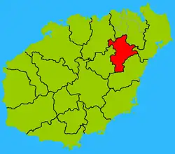 Location of the county | |
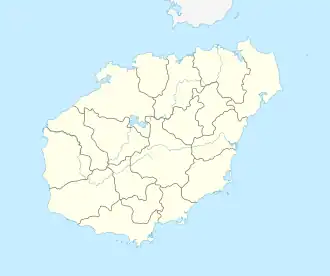 Ding'an Location of the seat in Hainan | |
| Coordinates: 19°41′53″N 110°21′7″E / 19.69806°N 110.35194°E | |
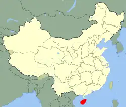
| Country | People's Republic of China |
| Province | Hainan |
| County seat | Dingcheng |
| Area | |
• Total | 1,189 km2 (459 sq mi) |
| Population (2002) | |
• Total | 304,522 |
| • Density | 260/km2 (660/sq mi) |
| Time zone | UTC+8 (China standard time) |
| Website | www |
Dìng'ān (Chinese: 定安; pinyin: Dìng'ān; postal: Tingan) is an administrative district in Hainan, People's Republic of China. It is one of 4 counties of Hainan. In 1999, its population was 304,522 people.
The town of Dingcheng is the main population center.
Climate
Ding'an a tropical monsoon climate (Köppen Am).
| Climate data for Ding'an, elevation 53 m (174 ft), (1991–2020 normals, extremes 1981–2010) | |||||||||||||
|---|---|---|---|---|---|---|---|---|---|---|---|---|---|
| Month | Jan | Feb | Mar | Apr | May | Jun | Jul | Aug | Sep | Oct | Nov | Dec | Year |
| Record high °C (°F) | 33.5 (92.3) |
36.2 (97.2) |
37.2 (99.0) |
40.0 (104.0) |
39.2 (102.6) |
39.0 (102.2) |
39.4 (102.9) |
37.3 (99.1) |
37.6 (99.7) |
35.3 (95.5) |
34.5 (94.1) |
32.5 (90.5) |
40.0 (104.0) |
| Mean daily maximum °C (°F) | 22.6 (72.7) |
24.4 (75.9) |
27.8 (82.0) |
30.9 (87.6) |
33.1 (91.6) |
34.0 (93.2) |
33.8 (92.8) |
33.1 (91.6) |
31.7 (89.1) |
29.5 (85.1) |
26.9 (80.4) |
23.3 (73.9) |
29.3 (84.7) |
| Daily mean °C (°F) | 18.3 (64.9) |
19.9 (67.8) |
22.9 (73.2) |
25.9 (78.6) |
27.8 (82.0) |
28.8 (83.8) |
28.7 (83.7) |
28.1 (82.6) |
27.1 (80.8) |
25.2 (77.4) |
22.7 (72.9) |
19.3 (66.7) |
24.6 (76.2) |
| Mean daily minimum °C (°F) | 15.6 (60.1) |
17.1 (62.8) |
19.9 (67.8) |
22.7 (72.9) |
24.6 (76.3) |
25.5 (77.9) |
25.5 (77.9) |
25.1 (77.2) |
24.4 (75.9) |
22.5 (72.5) |
20.0 (68.0) |
16.8 (62.2) |
21.6 (71.0) |
| Record low °C (°F) | 5.8 (42.4) |
7.5 (45.5) |
6.1 (43.0) |
14.6 (58.3) |
16.9 (62.4) |
20.9 (69.6) |
21.0 (69.8) |
21.8 (71.2) |
19.3 (66.7) |
14.3 (57.7) |
9.3 (48.7) |
5.0 (41.0) |
5.0 (41.0) |
| Average precipitation mm (inches) | 25.7 (1.01) |
31.2 (1.23) |
40.2 (1.58) |
125.2 (4.93) |
255.1 (10.04) |
234.7 (9.24) |
266.5 (10.49) |
324.0 (12.76) |
302.0 (11.89) |
272.6 (10.73) |
54.3 (2.14) |
42.2 (1.66) |
1,973.7 (77.7) |
| Average precipitation days (≥ 0.1 mm) | 9.5 | 9.4 | 9.3 | 12.1 | 17.5 | 16.6 | 16.5 | 18.6 | 16.3 | 11.4 | 9.2 | 9.1 | 155.5 |
| Average relative humidity (%) | 86 | 85 | 84 | 82 | 82 | 81 | 81 | 84 | 86 | 84 | 84 | 84 | 84 |
| Mean monthly sunshine hours | 87.7 | 96.1 | 131.9 | 162.6 | 202.2 | 208.5 | 220.8 | 195.6 | 155.7 | 146.1 | 109.7 | 87.0 | 1,803.9 |
| Percentage possible sunshine | 26 | 30 | 35 | 43 | 50 | 52 | 54 | 50 | 43 | 41 | 33 | 26 | 40 |
| Source: China Meteorological Administration[1][2] | |||||||||||||
See also
Wikimedia Commons has media related to Ding'an.
References
- ^ 中国气象数据网 – WeatherBk Data (in Simplified Chinese). China Meteorological Administration. Retrieved 17 June 2023.
- ^ 中国气象数据网 (in Simplified Chinese). China Meteorological Administration. Retrieved 17 June 2023.
- Harvard University Committee on the Environment (1999). "China County & City Population 1999 FAQ". Archived from the original on 2016-01-09.
19°41′53″N 110°21′07″E / 19.698°N 110.352°E
County-level divisions of Hainan | ||||||||||||||||||
|---|---|---|---|---|---|---|---|---|---|---|---|---|---|---|---|---|---|---|
| Prefecture-level cities |
|  | ||||||||||||||||
| Provincial administered |
| |||||||||||||||||