Doldersum
Doldersum | |
|---|---|
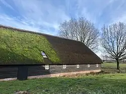 Farm in Doldersum | |
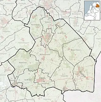
 The village (dark red) and the statistical district (light green) of Doldersum in the municipality of Westerveld. | |
 Doldersum Location in province of Drenthe in the Netherlands  Doldersum Doldersum (Netherlands) | |
| Coordinates: 52°53′N 6°15′E / 52.883°N 6.250°E | |
| Country | Netherlands |
| Province | Drenthe |
| Municipality | Westerveld |
| Area | |
• Total | 9.28 km2 (3.58 sq mi) |
| Elevation | 6 m (20 ft) |
| Population (2021)[1] | |
• Total | 125 |
| • Density | 13/km2 (35/sq mi) |
| Time zone | UTC+1 (CET) |
| • Summer (DST) | UTC+2 (CEST) |
| Postal code | 8386[1] |
| Dialing code | 0521 |
Doldersum is a hamlet in the Dutch province of Drenthe. It is a part of the municipality of Westerveld, and lies about 24 km northwest of Hoogeveen.
It was first mentioned in 1402 as Doldersem. The etymology is unknown.[3]
On 7 to 8 September 1944, 21 young men escaped from a forced labour camp in Vledder. The resistance hid them in the forest of Doldersum. One of the hiding places was discovered, and seven were shot. One survived, but remained handicapped. A monument has been placed on the heath in their honour.[4]
References
- ^ a b c "Kerncijfers wijken en buurten 2021". Central Bureau of Statistics. Retrieved 12 March 2022.
- ^ "Postcodetool for 8386XA". Actueel Hoogtebestand Nederland (in Dutch). Het Waterschapshuis. Retrieved 10 March 2022.
- ^ "Doldersum - (geografische naam)". Etymologiebank (in Dutch). Retrieved 12 March 2022.
- ^ "Doldersum". Plaatsengids (in Dutch). Retrieved 12 March 2022.
Wikimedia Commons has media related to Doldersum.