Doulaincourt-Saucourt
Doulaincourt-Saucourt | |
|---|---|
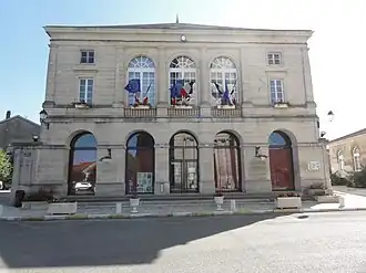 The town hall in Doulaincourt-Saucourt | |
 Coat of arms | |
Location of Doulaincourt-Saucourt | |
 Doulaincourt-Saucourt  Doulaincourt-Saucourt | |
| Coordinates: 48°19′25″N 5°12′24″E / 48.3236°N 5.2067°E | |
| Country | France |
| Region | Grand Est |
| Department | Haute-Marne |
| Arrondissement | Saint-Dizier |
| Canton | Bologne |
| Intercommunality | Meuse Rognon |
| Government | |
| • Mayor (2020–2026) | Frédéric Fabre[1] |
Area 1 | 43.86 km2 (16.93 sq mi) |
| Population (2022)[2] | 753 |
| • Density | 17/km2 (44/sq mi) |
| Time zone | UTC+01:00 (CET) |
| • Summer (DST) | UTC+02:00 (CEST) |
| INSEE/Postal code | 52177 /52270 |
| Elevation | 207–389 m (679–1,276 ft) (avg. 220 m or 720 ft) |
| 1 French Land Register data, which excludes lakes, ponds, glaciers > 1 km2 (0.386 sq mi or 247 acres) and river estuaries. | |
Doulaincourt-Saucourt (French pronunciation: [dulɛ̃kuʁ sokuʁ]) is a commune in the Haute-Marne department in north-eastern France. It was created in 1972 by the merger of two former communes: Doulaincourt and Saucourt-sur-Rognon.[3]
See also


References
Wikimedia Commons has media related to Doulaincourt-Saucourt.
- ^ "Répertoire national des élus: les maires" (in French). data.gouv.fr, Plateforme ouverte des données publiques françaises. 13 September 2022.
- ^ "Populations de référence 2022" (in French). The National Institute of Statistics and Economic Studies. 19 December 2024.
- ^ Modifications aux circonscriptions administratives territoriales (fusion de communes), Journal officiel de la République française n° 0131, 6 June 1972, p. 5668.