Drogen
Drogen | |
|---|---|
 | |
Location of Drogen | |
 Drogen  Drogen | |
| Coordinates: 50°55′3″N 12°18′59″E / 50.91750°N 12.31639°E | |
| Country | Germany |
| State | Thuringia |
| District | Altenburger Land |
| Town | Schmölln |
| Area | |
• Total | 4.26 km2 (1.64 sq mi) |
| Elevation | 265 m (869 ft) |
| Population (2017-12-31) | |
• Total | 123 |
| • Density | 29/km2 (75/sq mi) |
| Time zone | UTC+01:00 (CET) |
| • Summer (DST) | UTC+02:00 (CEST) |
| Postal codes | 04626 |
| Dialling codes | 034491 |
| Vehicle registration | ABG |
Drogen is a village and a former municipality in the district Altenburger Land, in Thuringia, Germany. Since 1 January 2019, it is part of the town Schmölln.[1]
Geography
Neighboring municipalities
Municipalities near Drogen include Altkirchen, Dobitschen, Nöbdenitz, the city of Schmölln, and Wildenbörten.
Municipal organization
The municipality of Drogen consisted of two subdivisions: Drogen and Mohlis.
Trivia
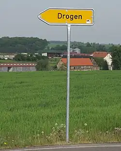
Drogen has an unusual name (It means Drugs in German), which has resulted in its street sign being frequently stolen.[2]
References
- ^ "Gebietsänderungen von Januar bis Dezember 2019". Statistisches Bundesamt (in German). 23 November 2023. Retrieved 27 February 2024.
- ^ Land, PI Altenburger (4 January 2016). ""Drogen" geklaut: Die Gemeinde Drogen hat schon wieder mal kein Ortsschild mehr". Ostthüringer Zeitung (in German). Retrieved 27 February 2024.
Wikimedia Commons has media related to Drogen.