Duingen
Duingen | |
|---|---|
 Coat of arms | |
Location of Duingen within Hildesheim district 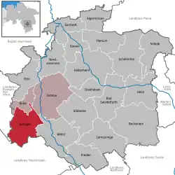 | |
 Duingen 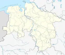 Duingen | |
| Coordinates: 52°00′N 09°42′E / 52.000°N 9.700°E | |
| Country | Germany |
| State | Lower Saxony |
| District | Hildesheim |
| Municipal assoc. | Leinebergland |
| Area | |
• Total | 59.62 km2 (23.02 sq mi) |
| Elevation | 193 m (633 ft) |
| Population (2023-12-31)[1] | |
• Total | 4,746 |
| • Density | 80/km2 (210/sq mi) |
| Time zone | UTC+01:00 (CET) |
| • Summer (DST) | UTC+02:00 (CEST) |
| Postal codes | 31089 |
| Dialling codes | 05185 |
| Vehicle registration | HI |
| Website | www.Duingen.de |
Duingen is a village and a municipality in the district of Hildesheim, in Lower Saxony, Germany. It is situated approximately 25 km southwest of Hildesheim, and 40 km south of Hanover. Since 1 November 2016, the former municipalities Coppengrave, Hoyershausen, Marienhagen and Weenzen are part of the municipality Duingen.
Duingen was the seat of the former Samtgemeinde ("collective municipality") Duingen.
References
Towns and municipalities in Hildesheim district | ||
|---|---|---|
 | ||