Eichgraben
Eichgraben | |
|---|---|
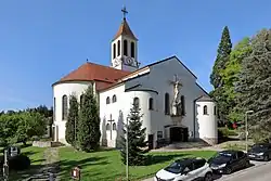 Roman Catholic Heart of Jesus Peace Church in Eichgraben named "Duomo of Vienna Woods" | |
 Coat of arms | |
 Eichgraben Location within Austria | |
| Coordinates: 48°10′22″N 15°59′0″E / 48.17278°N 15.98333°E | |
| Country | Austria |
| State | Lower Austria |
| District | Sankt Pölten-Land |
| Government | |
| • Mayor | Georg Ockermüller |
| Elevation | 286 m (938 ft) |
| Population (2018-01-01)[1] | |
• Total | 4,614 |
| Time zone | UTC+1 (CET) |
| • Summer (DST) | UTC+2 (CEST) |
| Postal code | 3032 |
| Area code | 02773 |
| Website | http://www.eichgraben.at |
Eichgraben is a town in the district of Sankt Pölten-Land in the Austrian state of Lower Austria.
Geography
Populated places
The municipality of Eichgraben consists of the following cadastral communities: Eichgraben; while further subdivided into populated places (with population in brackets as of 1 January 2024).
- Eichgraben (250)
- Hinterleiten (1361)
- Hutten (1477)
- Ottenheim (961)
- Stein (631)
- Winkl (113)
Population
| Year | Pop. | ±% |
|---|---|---|
| 1794 | 346 | — |
| 1830 | 354 | +2.3% |
| 1869 | 578 | +63.3% |
| 1880 | 583 | +0.9% |
| 1890 | 636 | +9.1% |
| 1900 | 874 | +37.4% |
| 1910 | 1,303 | +49.1% |
| 1923 | 1,380 | +5.9% |
| 1934 | 1,737 | +25.9% |
| 1939 | 1,822 | +4.9% |
| 1951 | 2,118 | +16.2% |
| 1961 | 2,050 | −3.2% |
| 1971 | 2,321 | +13.2% |
| 1981 | 2,642 | +13.8% |
| 1991 | 3,344 | +26.6% |
| 2001 | 3,748 | +12.1% |
| 2011 | 4,353 | +16.1% |
| 2021 | 4,783 | +9.9% |
References
- ^ "Einwohnerzahl 1.1.2018 nach Gemeinden mit Status, Gebietsstand 1.1.2018". Statistics Austria. Retrieved 9 March 2019.