Elands Bay
Elands Bay | |
|---|---|
.jpg) Baboon Point, Elands Bay | |
 Elands Bay  Elands Bay | |
| Coordinates: 32°18′S 18°19′E / 32.300°S 18.317°E | |
| Country | South Africa |
| Province | Western Cape |
| District | West Coast |
| Municipality | Cederberg |
| Area | |
• Total | 3.76 km2 (1.45 sq mi) |
| Population (2011)[1] | |
• Total | 1,525 |
| • Density | 410/km2 (1,100/sq mi) |
| Racial makeup (2011) | |
| • Black African | 30.6% |
| • Coloured | 60.1% |
| • Indian/Asian | 1.4% |
| • White | 7.5% |
| • Other | 0.3% |
| First languages (2011) | |
| • Afrikaans | 74.7% |
| • Xhosa | 17.1% |
| • English | 4.0% |
| • Other | 4.2% |
| Time zone | UTC+2 (SAST) |
| PO box | 8110 |
| Area code | 022 |
Elands Bay is a town in South Africa, situated in the Western Cape Province, on the Atlantic Ocean, at 32°18′S 18°19′E / 32.300°S 18.317°E. The town is located about 220 kilometres (two and a half hours drive) north from Cape Town. It is a world class surfing location and is also noted for its caves, which have a number of rock paintings.[2]
In 2009, Heritage Western Cape declared the Elands Bay Cave and most of Baboon Point (Cape Deseada), on which it is located, as a provincial heritage site.[3] Eland's Bay along with much of this coastline is an "important" bird habitat. The local wetland, Verlorenvlei, is a Ramsar wetland.
-
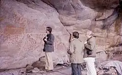 Cave at Eland's Bay
See also
- Mussel Point, a large "prehistoric" shell midden near Elands Bay
- Verlorevlei River
- Elands Bay Cave
References
- ^ a b c d "Main Place Elands Bay". Census 2011.
- ^ Parkington, John (1981). Pattern of the past: studies in honour of David Clarke. Cambridge University Press. pp. 341–57. ISBN 0-521-22763-1.
- ^ Provincial Notice 4619,Province of the Western Cape Provincial Gazette, No. 6621, Cape Town: 9 April 2009, p.549
External links
![]() Media related to Elands Bay at Wikimedia Commons
Media related to Elands Bay at Wikimedia Commons
- Official website
- Roadmap to Elandsbay
- Elandsbay Backpackers & Information
- National Heritage Resources Act 25 of 1999
Municipalities and communities of West Coast District Municipality, Western Cape | ||
|---|---|---|
District seat: Moorreesburg | ||
| Matzikama | .svg.png) | |
| Cederberg | ||
| Bergrivier | ||
| Saldanha Bay | ||
| Swartland | ||