Elphinstone railway station
Elphinstone | ||||||||||||||||
|---|---|---|---|---|---|---|---|---|---|---|---|---|---|---|---|---|
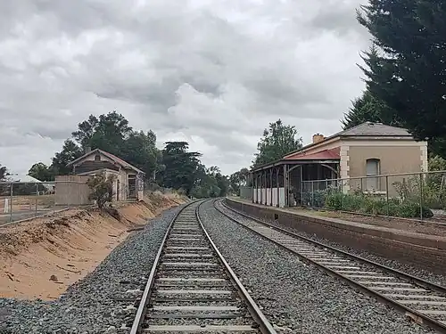 Elphinstone railway station, 2022 | ||||||||||||||||
| General information | ||||||||||||||||
| Line(s) | Bendigo | |||||||||||||||
| Platforms | 2 | |||||||||||||||
| Tracks | 2 | |||||||||||||||
| Other information | ||||||||||||||||
| Status | Closed | |||||||||||||||
| History | ||||||||||||||||
| Opened | 21 October 1862 | |||||||||||||||
| Closed | 4 October 1981 | |||||||||||||||
| Services | ||||||||||||||||
| ||||||||||||||||
Elphinstone railway station was located on the Bendigo line, serving the Victorian town of the same name. The station opened in October 1862,[1] and was closed to passenger traffic on 4 October 1981, as part of the New Deal timetable for country passengers.[2]
The Elphinstone station building is listed by the National Trust, and there are only two other similar ones in Victoria. It is a single-storey brick building with a hipped roof, quoining, and rendered window dressings with stone sills. A goods shed, with polychrome brickwork and granite trimmings, is situated at the Melbourne end of the main platform. It is equipped with a hand-operated crane dating back to the opening of the line.[3] The station building is now leased as a private residence.
In 1988, all points and signals, and the interlocked signal frame, were abolished.[4] The double line block sections,[5] Kyneton to Elphinstone and Elphinstone to Castlemaine "A" signal box, were abolished, and replaced with a double line block section, Kyneton to Castlemaine "A" box.[4]
References
- ^ "Elphinstone". Vicsig. Retrieved 14 July 2023.
- ^ Martin, Scott; Banger, Chris (October 2006). "'New Deal' for Country Passengers – 25 years on". Newsrail. Australian Railway Historical Society (Victorian Division). p. 319.
- ^ "Railway Station & Goods Shed". National Trust of Australia (Victoria). Retrieved 31 October 2024.
- ^ a b "Works". Newsrail. Australian Railway Historical Society (Victorian Division). August 1988. p. 252.
- ^ "Double Line Block System". Vicsig. Retrieved 31 October 2024.
External links
- Melway map at street-directory.com.au
37°06′10″S 144°20′00″E / 37.1028°S 144.3332°E