Eltendorf
Eltendorf | |
|---|---|
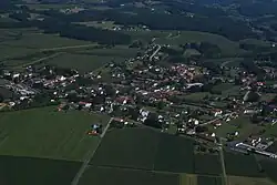 Aerial view | |
 Coat of arms | |
 Location within Jennersdorf district | |
 Eltendorf Location within Austria | |
| Coordinates: 47°1′N 16°12′E / 47.017°N 16.200°E | |
| Country | Austria |
| State | Burgenland |
| District | Jennersdorf |
| Government | |
| • Mayor | Christian Schaberl (LBL) |
| Area | |
• Total | 20.58 km2 (7.95 sq mi) |
| Elevation | 246 m (807 ft) |
| Population (2018-01-01)[2] | |
• Total | 954 |
| • Density | 46/km2 (120/sq mi) |
| Time zone | UTC+1 (CET) |
| • Summer (DST) | UTC+2 (CEST) |
| Postal code | 7562 |
| Website | https://www.eltendorf.at/ |
Eltendorf (Hungarian: Ókörtvélyes, Ó-Körtvélyes, Slovene: Gruškova Ves) is a town in the district of Jennersdorf in the Austrian state of Burgenland.
Geography
Cadastral communities are Eltendorf and Zahling.[3]
Population
| Year | Pop. | ±% |
|---|---|---|
| 1869 | 1,884 | — |
| 1880 | 1,885 | +0.1% |
| 1890 | 1,935 | +2.7% |
| 1900 | 1,678 | −13.3% |
| 1910 | 1,652 | −1.5% |
| 1923 | 1,465 | −11.3% |
| 1934 | 1,886 | +28.7% |
| 1939 | 1,448 | −23.2% |
| 1951 | 1,267 | −12.5% |
| 1961 | 1,217 | −3.9% |
| 1971 | 1,122 | −7.8% |
| 1981 | 1,029 | −8.3% |
| 1991 | 977 | −5.1% |
| 2001 | 1,017 | +4.1% |
| 2011 | 968 | −4.8% |
References
- ^ "Dauersiedlungsraum der Gemeinden Politischen Bezirke und Bundesländer - Gebietsstand 1.1.2018". Statistics Austria. Retrieved 10 March 2019.
- ^ "Einwohnerzahl 1.1.2018 nach Gemeinden mit Status, Gebietsstand 1.1.2018". Statistics Austria. Retrieved 9 March 2019.
- ^ Katastralgemeindenverzeichnis, www.bev.gv.at