Ernsthofen
Ernsthofen | |
|---|---|
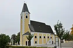 Catholic church in Ernsthofen | |
 Coat of arms | |
 Ernsthofen Location within Austria | |
| Coordinates: 48°8′N 14°29′E / 48.133°N 14.483°E | |
| Country | Austria |
| State | Lower Austria |
| District | Amstetten |
| Government | |
| • Mayor | Karl Huber |
| Area | |
• Total | 17.79 km2 (6.87 sq mi) |
| Elevation | 264 m (866 ft) |
| Population (2018-01-01)[2] | |
• Total | 2,230 |
| • Density | 130/km2 (320/sq mi) |
| Time zone | UTC+1 (CET) |
| • Summer (DST) | UTC+2 (CEST) |
| Postal code | 4432 |
| Area code | 07435 |
| Website | www.ernsthofen.at |
Ernsthofen is a town in the district of Amstetten in Lower Austria in Austria.
Population
| Year | Pop. | ±% |
|---|---|---|
| 1869 | 1,075 | — |
| 1880 | 1,100 | +2.3% |
| 1890 | 1,120 | +1.8% |
| 1900 | 1,202 | +7.3% |
| 1910 | 1,177 | −2.1% |
| 1923 | 1,238 | +5.2% |
| 1934 | 1,262 | +1.9% |
| 1939 | 1,279 | +1.3% |
| 1951 | 1,316 | +2.9% |
| 1961 | 1,504 | +14.3% |
| 1971 | 1,745 | +16.0% |
| 1981 | 1,825 | +4.6% |
| 1991 | 2,004 | +9.8% |
| 2001 | 2,105 | +5.0% |
| 2005 | 2,177 | +3.4% |
References
- ^ "Dauersiedlungsraum der Gemeinden Politischen Bezirke und Bundesländer - Gebietsstand 1.1.2018". Statistics Austria. Retrieved 10 March 2019.
- ^ Population at the beginning of the year for municipalities since 2002 (in German), Statistics Austria, January 2023, Wikidata Q27838750