Faraba, Kayes
Faraba | |
|---|---|
Commune and village | |
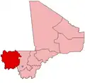
 Faraba Location in Mali | |
| Coordinates: 12°26′4″N 10°53′54″W / 12.43444°N 10.89833°W[1] | |
| Country | |
| Region | Kayes Region |
| Cercle | Kéniéba Cercle |
| Area | |
• Total | 1,167 km2 (451 sq mi) |
| Population (2009 census)[3] | |
• Total | 8,563 |
| • Density | 7.3/km2 (19/sq mi) |
| Time zone | UTC+0 (GMT) |
Faraba is a village and rural commune in the Cercle of Kéniéba in the Kayes Region of south-western Mali. The commune includes 12 villages[4] and in the 2009 census had a population of 8,563.[3]
References
- ^ Common and Fundamental Operational Datasets Registry: Mali, United Nations Office for the Coordination of Humanitarian Affairs, archived from the original on 2012-01-06. See cheflieu_mali.zip
- ^ Common and Fundamental Operational Datasets Registry: Mali, United Nations Office for the Coordination of Humanitarian Affairs, archived from the original on 2012-01-06. commune_mali.zip (Originally from the Direction Nationale des Collectivités Territoriales, République du Mali)
- ^ a b Resultats Provisoires RGPH 2009 (Région de Kayes) (PDF) (in French), République de Mali: Institut National de la Statistique, archived from the original (PDF) on 2012-07-27
{{citation}}: CS1 maint: publisher location (link). - ^ Communes de la Région de Kayes (PDF) (in French), Ministère de l’administration territoriale et des collectivités locales, République du Mali, archived from the original (PDF) on 2012-03-09.
External links
- Plan de Sécurité Alimentaire Commune Rurale de Faraba 2007-2011 (PDF) (in French), Commissariat à la Sécurité Alimentaire, République du Mali, USAID-Mali, 2006, archived from the original (PDF) on 2012-09-02, retrieved 2012-05-13.