Farner, Tennessee
Farner, Tennessee | |
|---|---|
 Farner | |
 Farner, Tennessee  Farner, Tennessee | |
| Coordinates: 35°09′15″N 84°18′55″W / 35.15417°N 84.31528°W | |
| Country | United States |
| State | Tennessee |
| County | Polk |
| Area | |
• Total | 1.46 sq mi (3.78 km2) |
| • Land | 1.46 sq mi (3.78 km2) |
| • Water | 0.00 sq mi (0.00 km2) |
| Elevation | 1,598 ft (487 m) |
| Population | |
• Total | 267 |
| • Density | 182.88/sq mi (70.61/km2) |
| Time zone | UTC-5 (Eastern (EST)) |
| • Summer (DST) | UTC-4 (EDT) |
| ZIP code | 37333 |
| Area code | 423 |
| GNIS feature ID | 1328174[3] |
Farner is an unincorporated community in Polk County, Tennessee, United States. Farner is located in a mountainous area along Tennessee State Route 68 near the North Carolina border, 9 miles (14 km) north-northeast of Ducktown.[4] Farner has a post office with ZIP code 37333.[5] The Hiwassee River and Apalachia Dam are located just to the north.
Demographics
| Census | Pop. | Note | %± |
|---|---|---|---|
| 2020 | 267 | — | |
| U.S. Decennial Census[6] | |||
References
- ^ "ArcGIS REST Services Directory". United States Census Bureau. Retrieved October 15, 2022.
- ^ "Census Population API". United States Census Bureau. Retrieved October 15, 2022.
- ^ "Farner". Geographic Names Information System. United States Geological Survey, United States Department of the Interior.
- ^ Polk County, Tennessee General Highway Map (PDF) (Map). Tennessee Department of Transportation. 2004. Archived from the original (PDF) on April 19, 2012. Retrieved March 16, 2012.
- ^ United States Postal Service (2012). "USPS - Look Up a ZIP Code". Retrieved February 15, 2012.
- ^ "Census of Population and Housing". Census.gov. Retrieved June 4, 2016.
Municipalities and communities of Polk County, Tennessee, United States | ||
|---|---|---|
| Cities | 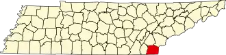 | |
| Town | ||
| CDPs | ||
| Other communities | ||
| Footnotes | ‡This populated place also has portions in an adjacent county or counties | |