Feres, Magnesia
Feres
Φερές | |
|---|---|
 Feres Location within the regional unit 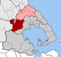 | |
| Coordinates: 39°22′N 22°44′E / 39.367°N 22.733°E | |
| Country | Greece |
| Administrative region | Thessaly |
| Regional unit | Magnesia |
| Municipality | Rigas Feraios |
| Area | |
| • Municipal unit | 215.5 km2 (83.2 sq mi) |
| Elevation | 120 m (390 ft) |
| Population (2021)[1] | |
| • Municipal unit | 4,746 |
| • Municipal unit density | 22/km2 (57/sq mi) |
| Time zone | UTC+2 (EET) |
| • Summer (DST) | UTC+3 (EEST) |
| Postal code | 37 500 |
| Area code(s) | 24250 |
| Vehicle registration | ΒΟ |
Feres (Greek: Φερές; Katharevousa: Φεραί) is a former municipality in Magnesia, Thessaly, Greece. Since the 2011 local government reform it is part of the municipality Rigas Feraios, of which it is a municipal unit.[2] The municipal unit has an area of 215.513 km2.[3] Population 4,746 (2021). The seat of the municipality was in the town Velestino.
Feres is located near the ancient city of Pherae, after which it was named.
Notable people
- Rigas Feraios (1757–1798), Greek Enlightenment writer and revolutionary
References
- ^ "Αποτελέσματα Απογραφής Πληθυσμού - Κατοικιών 2021, Μόνιμος Πληθυσμός κατά οικισμό" [Results of the 2021 Population - Housing Census, Permanent population by settlement] (in Greek). Hellenic Statistical Authority. 29 March 2024.
- ^ "ΦΕΚ B 1292/2010, Kallikratis reform municipalities" (in Greek). Government Gazette.
- ^ "Population & housing census 2001 (incl. area and average elevation)" (PDF) (in Greek). National Statistical Service of Greece. Archived from the original (PDF) on 2015-09-21.