Ferrières, Belgium
Ferrières
Ferire (Walloon) | |
|---|---|
 | |
 Flag .svg.png) Coat of arms | |
Location of Ferrières | |
 Ferrières Location in Belgium
Location of Ferrières in the province of Liège 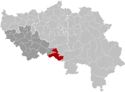 | |
| Coordinates: 50°24′N 05°36′E / 50.400°N 5.600°E | |
| Country | Belgium |
| Community | French Community |
| Region | |
| Province | |
| Arrondissement | Huy |
| Government | |
| • Mayor | Frédéric LEONARD (RpF) |
| • Governing party/ies | RpF |
| Area | |
• Total | 57.06 km2 (22.03 sq mi) |
| Population (2018-01-01)[1] | |
• Total | 4,918 |
| • Density | 86/km2 (220/sq mi) |
| Postal codes | 4190 |
| NIS code | 61019 |
| Area codes | 086 and 04 |
| Website | www.ferrieres.be |
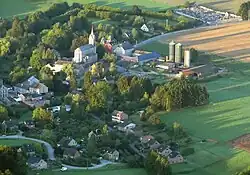
Ferrières (French pronunciation: [fɛʁjɛʁ] ⓘ; Walloon: Ferire) is a municipality of Wallonia located in the province of Liège, Belgium.
On January 1, 2006, Ferrières had a total population of 4,449. The total area is 56.90 km2 with a population density of 78 inhabitants per km2.
The municipality consists of the following districts: Ferrières, My (pronounced "Mee"), Vieuxville (including the hamlet of Sy), Werbomont, and Xhoris.
See also
References
- ^ "Wettelijke Bevolking per gemeente op 1 januari 2018". Statbel. Retrieved 9 March 2019.
External links
 Media related to Ferrières at Wikimedia Commons
Places adjacent to Ferrières, Belgium | |
|---|---|
Municipalities in the province of Liège, Wallonia | ||
|---|---|---|
| Huy | 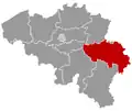 | |
| Liège | ||
| Verviers | ||
| Waremme | ||
| ||