Fier District
Fier District
Rrethi i Fierit | |
|---|---|
 | |
| Coordinates: 40°42′N 19°32′E / 40.700°N 19.533°E | |
| Country | |
| Dissolved | 2000 |
| Seat | Fier |
| Area | |
• Total | 850 km2 (330 sq mi) |
| Population (2001) | |
• Total | 200,154 |
| • Density | 240/km2 (610/sq mi) |
| Time zone | UTC+1 (CET) |
| • Summer (DST) | UTC+2 (CEST) |
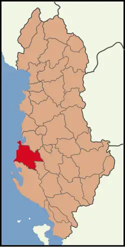
Fier District (Albanian: Rrethi i Fierit) was one of the 36 districts of Albania, which were dissolved in July 2000 and replaced by 12 counties. It had a population of 200,154 in 2001, and an area of 850 km2 (330 sq mi).[1] Located in the south-west of the country, its capital was the city of Fier. Its territory is now part of Fier County: the municipalities of Fier, Patos and Roskovec.
Administrative divisions
The district consisted of the following municipalities:[2]
References
- ^ Districts of Albania, statoids.com
- ^ "Portraits of poverty and inequality in Albania" (PDF). World Bank Group. 2016. pp. 33–40.
Districts in Albania were geographic divisions made up of cities, towns and villages. They were abolished in 2000. | |
| (36) | |