Forest City, Minnesota
Forest City, Minnesota | |
|---|---|
 Forest City  Forest City | |
| Coordinates: 45°12′23″N 94°27′59″W / 45.20639°N 94.46639°W | |
| Country | United States |
| State | Minnesota |
| County | Meeker |
| Township | Forest City |
| Elevation | 1,070 ft (330 m) |
| Time zone | UTC-6 (Central (CST)) |
| • Summer (DST) | UTC-5 (CDT) |
| ZIP code | 55355 and 55389 |
| Area code | 320 |
| GNIS feature ID | 643796[1] |
Forest City is an unincorporated community in Forest City Township, Meeker County, Minnesota, United States, near Litchfield and Watkins. The community is located along Meeker County Road 2 near its junction with State Highway 24 (MN 24). The North Fork of the Crow River flows nearby.
| Census | Pop. | Note | %± |
|---|---|---|---|
| 1870 | 181 | — | |
| U.S. Decennial Census[2] | |||
History
Forest City was platted in 1857, and named for its location near the Big Woods.[3] A post office was established at Forest City in 1856, and remained in operation until 1907.[4]
Forest City was attacked by Little Crow's band of Dakota during the 1862 Dakota War. Several buildings were burned, but the attack was unsuccessful.[5]
References
- ^ "Forest City, Minnesota". Geographic Names Information System. United States Geological Survey, United States Department of the Interior.
- ^ United States Census Bureau. "Census of Population and Housing".
- ^ Upham, Warren (1920). Minnesota Geographic Names: Their Origin and Historic Significance. Minnesota Historical Society. p. 339.
- ^ "Meeker County". Jim Forte Postal History. Archived from the original on July 21, 2015. Retrieved July 21, 2015.
- ^ https://www.co.meeker.mn.us/DocumentCenter/View/2418/Forest-City-Attack-Doc-071717.
{{cite web}}: Missing or empty|title=(help)
Terry Tales by Terry R. Shaw
Municipalities and communities of Meeker County, Minnesota, United States | ||
|---|---|---|
| Cities | 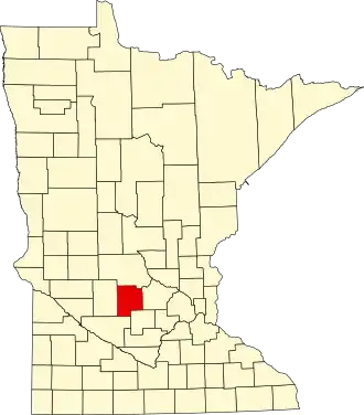 | |
| Townships | ||
| Unincorporated communities | ||
| Footnotes | ‡This populated place also has portions in an adjacent county or counties | |