Fort de Caluire
| Fort de Caluire | |
|---|---|
| Caluire-et-Cuire | |
 Entrance of fort | |
| Site information | |
| Type | Fort |
| Location | |
 Fort de Caluire | |
| Coordinates | 45°47′35″N 4°50′13″E / 45.793°N 4.837°E |
| Site history | |
| Built | 1831 |
| Architect | Hubert Rohault de Fleury (soldier) |
| In use | 1933 |
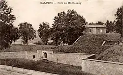
Fort de Caluire (French pronunciation: [fɔʁ də kalɥiʁ]) was an old fortification situated in Caluire-et-Cuire. Now demolished, it was part of the first belt of forts protecting Lyon.
History

Built in 1831, it was connected to the Fort de Montessuy by a long chamber, from which it defended the approaches to the Croix-Rousse along the road from the Dombes.
Placed on the slope of the Saône it defended the river, along with Fort de Loyasse, Fort Duchère and Fort Saint-Jean. It was square, with a bastion at each corner.
In the 1860s a mushroom farm operated in the underground enclosure connecting the two forts, with the old bastions repurposed into underground grow-rooms.[1] T
Today
The fort was demolished in 1933 to make way for the construction of the current Henri Cochet stadium. A few clues remain as to its location such as the present street known as the montée (rise or climb) des Forts; the entrance to fort de Caluire was at the current intersection of montée des Forts and avenue Paul Doumer.
-
 Wagon from the mushroom farm
 -
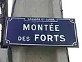 Street sign
 -
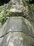 Traces of the fort
 -
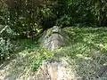 Fort ruins
See also
References
- ^ Association OCRA-LYON, ed. (7 November 2009), Visite de l'ancienne champignonnière de Caluire-et-Cuire (PDF) (in French), Lyon, archived from the original (PDF) on 25 November 2011, retrieved 28 July 2012
{{citation}}: CS1 maint: location missing publisher (link).
Bibliography
- Dallemagne, François; Georges Fessy (2006). Les défenses de Lyon: enceintes et fortifications (in French). Lyon: Éditions Lyonnaises d'Art et d'Histoire. pp. 124–126. ISBN 2-84147-177-2.