Fortress of Charlemont
| Fortress of Charlemont | |
|---|---|
Fort de Charlemont | |
| Near Givet | |
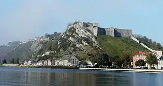 The Fortress of Charlemont and the village of Givet. | |
| Site information | |
| Type | Fort |
| Location | |
 Fortress of Charlemont (Champagne-Ardenne) | |
| Coordinates | 50°08′09″N 4°48′13″E / 50.135833°N 4.803611°E |
| Site history | |
| Built | 1555 |
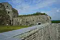
The Fortress of Charlemont (French: Fort de Charlemont) is a French stronghold located near the Belgian border on the Meuse. It is a citadel, surrounded by a network of outworks,[1] including the connecting forts (Givet and the Mont d'Hours).[2] It dominates the town of Givet and when in use as a working fortress controlled the valley of the Meuse.
-
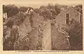 Destruction within the fort after the First World War.
 -
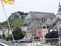 view of the fort from within Givet.
 -
 The Maugis Tower.
 -
 Between Condé Charlemont Covered Path.
 -
 Entrance to Fort Condé.
 -
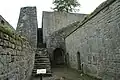 Staircase, the only access point from the glacis to the fort.
See also
- Reduction of the French fortresses in 1815 — this fortress was the last to surrender to the Coalition.
- Meuse Citadels — a group of forts situated along the Meuse river in southern Belgium.
Notes
- ^ Montclos 2009, p. .
- ^ Siborne 1895, p. 780.
References
- Montclos, Jean-Marie Pérouse de (2009) [1972], Architecture. Méthode et vocabulaire (in French), Paris: du patrimoine (publishing heritage), ISBN 978-2-85822-593-4
- Siborne, William (1895), The Waterloo Campaign, 1815 (4th ed.), Westminster: A. Constable