Nogueira, Fraião e Lamaçães
Nogueira, Fraião e Lamaçães | |
|---|---|
 Nogueira, Fraião e Lamaçães Location in Portugal | |
| Coordinates: 41°31′41″N 8°24′47″W / 41.528°N 8.413°W | |
| Country | |
| Region | Norte |
| Intermunic. comm. | Cávado |
| District | Braga |
| Municipality | Braga |
| Area | |
• Total | 8.40 km2 (3.24 sq mi) |
| Population (2011) | |
• Total | 13,054 |
| • Density | 1,600/km2 (4,000/sq mi) |
| Time zone | UTC+00:00 (WET) |
| • Summer (DST) | UTC+01:00 (WEST) |
Nogueira, Fraião e Lamaçães is a civil parish in the municipality of Braga, Portugal. It was formed in 2013 by the merger of the former parishes Nogueira, Fraião and Lamaçães.[1] The population in 2011 was 13,054,[2] in an area of 8.40 km2.[3] The Fountain of Águas Ferreas is situated in the village Fraião.
-
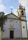 Nogueira Church
 -
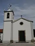 Fraião Church
 -
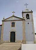 Lamaçães Church
References
- ^ Diário da República. "Law nr. 11-A/2013, pages 552 26-28" (pdf) (in Portuguese). Retrieved 18 July 2014.
- ^ Instituto Nacional de Estatística (INE), Census 2011 results according to the 2013 administrative division of Portugal
- ^ "Áreas das freguesias, concelhos, distritos e país". Archived from the original on 2018-11-05. Retrieved 2018-11-05.