Fraxern
Fraxern | |
|---|---|
 | |
 Coat of arms | |
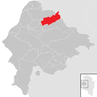 Location in the district | |
 Fraxern Location within Austria | |
| Coordinates: 47°19′N 09°40′E / 47.317°N 9.667°E | |
| Country | Austria |
| State | Vorarlberg |
| District | Feldkirch |
| Government | |
| • Mayor | Steve Mayr |
| Area | |
• Total | 8.87 km2 (3.42 sq mi) |
| Elevation | 817 m (2,680 ft) |
| Population (2018-01-01)[2] | |
• Total | 701 |
| • Density | 79/km2 (200/sq mi) |
| Time zone | UTC+1 (CET) |
| • Summer (DST) | UTC+2 (CEST) |
| Postal code | 6833 |
| Website | http://www.tisvover.at/fraxern/ |
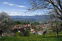
Fraxern is a municipality in the district of Feldkirch in the Austrian state of Vorarlberg.
Fraxern lies in the mountains next to Feldkirch at an altitude of 817 m. 54.6 % of the municipality is covered by forest and 26.7 % are meadows.
The first written mention of Fraxern ("Fraxnara", meaning ash), dates back to 1127.
Population
| Year | Pop. | ±% |
|---|---|---|
| 1869 | 341 | — |
| 1880 | 367 | +7.6% |
| 1890 | 356 | −3.0% |
| 1900 | 373 | +4.8% |
| 1910 | 400 | +7.2% |
| 1923 | 413 | +3.2% |
| 1934 | 411 | −0.5% |
| 1939 | 394 | −4.1% |
| 1951 | 430 | +9.1% |
| 1961 | 473 | +10.0% |
| 1971 | 484 | +2.3% |
| 1981 | 519 | +7.2% |
| 1991 | 592 | +14.1% |
| 2001 | 659 | +11.3% |
| 2011 | 674 | +2.3% |
| 2012 | 671 | −0.4% |
| 2013 | 660 | −1.6% |
| 2014 | 656 | −0.6% |
| 2015 | 687 | +4.7% |
References
- ^ "Dauersiedlungsraum der Gemeinden Politischen Bezirke und Bundesländer - Gebietsstand 1.1.2018". Statistics Austria. Retrieved 10 March 2019.
- ^ "Einwohnerzahl 1.1.2018 nach Gemeinden mit Status, Gebietsstand 1.1.2018". Statistics Austria. Retrieved 9 March 2019.
Wikimedia Commons has media related to Fraxern.