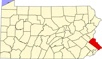
Furlong, Pennsylvania
Furlong, Pennsylvania | |
|---|---|
Unincorporated community | |
 Furlong  Furlong | |
| Coordinates: 40°17′46″N 75°4′56″W / 40.29611°N 75.08222°W | |
| Country | United States |
| State | Pennsylvania |
| County | Bucks |
| Township | Buckingham and Doylestown |
| Elevation | 312 ft (95 m) |
| Time zone | UTC-5 (Eastern (EST)) |
| • Summer (DST) | UTC-4 (EDT) |
| ZIP code | 18925 |
| Area codes | 215, 267 and 445 |
| GNIS feature ID | 1203644[1] |
Furlong is an unincorporated community in Bucks County, Pennsylvania, United States. Furlong is located at the intersection of Pennsylvania Route 263 and Edison-Furlong Road/Forest Grove Road on the border of Buckingham and Doylestown townships.[2]
References
- ^ "Furlong". Geographic Names Information System. United States Geological Survey, United States Department of the Interior.
- ^ Bucks County, Pennsylvania (Map) (19th ed.). 1"=2000'. ADC Map. 2006. p. 3035. § G3. ISBN 0-87530-774-4.