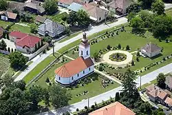
Garbolc
Garbolc | |
|---|---|
 | |
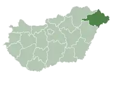
 Garbolc Location of Garbolc in Hungary | |
| Coordinates: 47°56′43″N 22°51′36″E / 47.94517°N 22.85993°E | |
| Country | Hungary |
| Region | Northern Great Plain |
| County | Szabolcs-Szatmár-Bereg |
| Subregion | Fehérgyarmati |
| Rank | Village |
| Area | |
• Total | 7.26 km2 (2.80 sq mi) |
| Population (1 January 2008)[2] | |
• Total | 148 |
| • Density | 20/km2 (53/sq mi) |
| Time zone | UTC+1 (CET) |
| • Summer (DST) | UTC+2 (CEST) |
| Postal code | 4976 |
| Area code | +36 44 |
| KSH code | 04996[1] |
| Website | https://garbolc.asp.lgov.hu/ |

Garbolc is a village in Szabolcs-Szatmár-Bereg county, Hungary. It is located near the easternmost geographical point (the Romanian-Ukrainian-Hungarian tripoint) of Hungary.
References
- ^ a b Garbolc at the Hungarian Central Statistical Office (Hungarian).
- ^ Garbolc at the Hungarian Central Statistical Office (Hungarian). 1 January 2008
47°57′N 22°52′E / 47.950°N 22.867°E