Gebsattel
Gebsattel | |
|---|---|
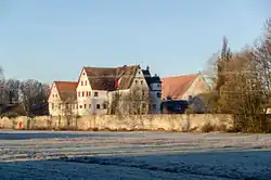 Gebsattel Castle | |
 Coat of arms | |
Location of Gebsattel within Ansbach district 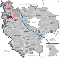 | |
 Gebsattel  Gebsattel | |
| Coordinates: 49°21′N 10°11′E / 49.350°N 10.183°E | |
| Country | Germany |
| State | Bavaria |
| Admin. region | Mittelfranken |
| District | Ansbach |
| Municipal assoc. | Rothenburg ob der Tauber |
| Subdivisions | 3 Ortsteile |
| Government | |
| • Mayor (2020–26) | Gerd Rößler[1] |
| Area | |
• Total | 19.12 km2 (7.38 sq mi) |
| Elevation | 378 m (1,240 ft) |
| Population (2024-12-31)[2] | |
• Total | 1,738 |
| • Density | 91/km2 (240/sq mi) |
| Time zone | UTC+01:00 (CET) |
| • Summer (DST) | UTC+02:00 (CEST) |
| Postal codes | 91607 |
| Dialling codes | 09861 |
| Vehicle registration | AN |
| Website | www.gebsattel.de |
Gebsattel is a municipality in the district of Ansbach in Bavaria in Germany. It lies on the Tauber River.
Main sights
-
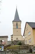 Catholic church of Saint Laurentius
 -
-26032012.JPG) One of the old gates
One of the old gates
Neighborhoods, districts
Gebsattel has nine neighborhoods or districts:[3]
- Bockenfeld
- Eckartshof
- Gebsattel
- Kirnberg
- Pleikartshof
- Rödersdorf
- Speierhof
- Wasenmühle
- Wildenhof
References
- ^ Liste der ersten Bürgermeister/Oberbürgermeister in kreisangehörigen Gemeinden, Bayerisches Landesamt für Statistik, 15 July 2021.
- ^ "Gemeinden, Kreise und Regierungsbezirke in Bayern, Einwohnerzahlen am 31. Dezember 2024; Basis Zensus 2022" [Municipalities, counties, and administrative districts in Bavaria; Based on the 2022 Census] (CSV) (in German). Bayerisches Landesamt für Statistik.
- ^ "Gebsattel | bavarikon".
External links
Wikimedia Commons has media related to Gebsattel.
- Map of the municipality
- "Gebsattel: History of the coat-of-arms" (in German). Haus der Bayerischen Geschichte.
- Gebsattel: Official statistics compiled by the Bavarian State Office of Statistics (LfStat)