Goforth, Kentucky
Goforth | |
|---|---|
 Goforth Location within the state of Kentucky  Goforth Goforth (the United States) | |
| Coordinates: 38°39′53″N 84°26′56″W / 38.66472°N 84.44889°W | |
| Country | United States |
| State | Kentucky |
| County | Pendleton |
| Area | |
• Total | 150.53 sq mi (389.87 km2) |
| • Land | 150.15 sq mi (388.89 km2) |
| • Water | 0.38 sq mi (0.98 km2) |
| Elevation | 922 ft (281 m) |
| Population (2000) | |
• Total | 8,044 |
| • Density | 53/sq mi (21/km2) |
| Time zone | UTC-5 (Eastern (EST)) |
| • Summer (DST) | UTC-4 (EST) |
| GNIS feature ID | 508105[1] |
Goforth is an unincorporated community located in Pendleton County, Kentucky, United States. Its post office [2] is closed.
References
Municipalities and communities of Pendleton County, Kentucky, United States | ||
|---|---|---|
| Cities | 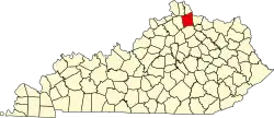 | |
| Unincorporated communities | ||
| Footnotes | ‡This populated place also has portions in an adjacent county or counties | |