Gogarth railway station
Gogarth | |||||
|---|---|---|---|---|---|
 | |||||
| General information | |||||
| Location | Eglwys Fach, Merionethshire Wales | ||||
| Platforms | 1 | ||||
| Other information | |||||
| Status | Disused | ||||
| History | |||||
| Original company | Great Western Railway | ||||
| Key dates | |||||
| 9 July 1923 | Station opens as Gogarth Halt | ||||
| 6 May 1968 | Station renamed Gogarth | ||||
| 14 May 1984 | Last Train | ||||
| 30 September 1985 | Station closes (officially) | ||||
| |||||
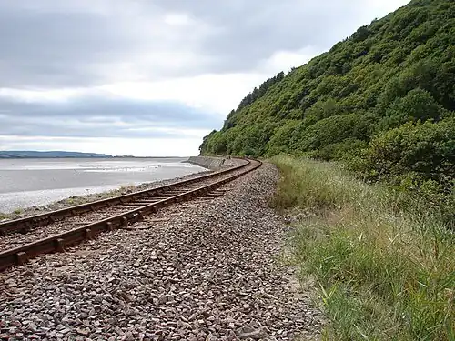
Gogarth railway station served a sparsely populated area on the north shore of the Dyfi estuary in the Welsh county of Merionethshire.
History
Opened by the Great Western Railway on 9 July 1923 and originally named Gogarth Halt, it had a short wooden platform with no shelter. The station passed on to the London Midland Region of British Railways on nationalisation in 1948. Renamed Gogarth on 6 May 1968, services were suspended from 14 May 1984 due to the deteriorating structural condition of the platform and cost of repairs needed.[1] The station was officially closed by the British Railways Board on 30 September 1985.[2]
The site today
Trains on the Cambrian Line pass the site of the former halt but there is no trace of its existence. Only the access path leading from a lay-by on the A493 road exists.
Notes
- ^ Slater, John, ed. (June 1984). "Cambrian halts decision". The Railway Magazine. 130 (998): 243.
- ^ Butt 1995, p. 106.
References
- Butt, R.V.J. (1995). The Directory of Railway Stations. Yeovil: Patrick Stephens Ltd. ISBN 1-85260-508-1. R508.
- A. Jowett (2000). Jowett's Nationalised Railway Atlas. Atlantic Publishing. ISBN 0-906899-99-0.
External links
| Preceding station | Historical railways | Following station | ||
|---|---|---|---|---|
| Dovey Junction Line and station open |
Great Western Railway | Abertafol Halt Line open, station closed | ||
52°33′39″N 3°57′40″W / 52.5608°N 3.9610°W