Good Hope, Ohio
Good Hope, Ohio | |
|---|---|
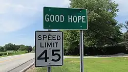
 Looking north on Ohio State Route 753 in Good Hope | |
 Good Hope  Good Hope | |
| Coordinates: 39°26′48″N 83°21′34″W / 39.44667°N 83.35944°W | |
| Country | United States |
| State | Ohio |
| County | Fayette |
| Township | Wayne |
| Area | |
• Total | 0.75 sq mi (1.95 km2) |
| • Land | 0.75 sq mi (1.95 km2) |
| • Water | 0.00 sq mi (0.00 km2) |
| Elevation | 935 ft (285 m) |
| Population (2020) | |
• Total | 202 |
| • Density | 268.26/sq mi (103.61/km2) |
| Time zone | UTC-5 (Eastern (EST)) |
| • Summer (DST) | UTC-4 (EDT) |
| FIPS code | 39-30828[3] |
| GNIS feature ID | 2628896[2] |
Good Hope is an unincorporated community and census-designated place (CDP) in central Wayne Township, Fayette County, Ohio, United States.[2] The population was 202 at the 2020 census.
History
Good Hope was platted in 1849, although a small village had already existed there for some time.[4] The community is said to have derived its name from Good Hope, Pennsylvania, the native home of a share of the early settlers.[5] A post office was established at Good Hope in 1851, and remained in operation until 1965.[6]
It was only in 2012 that Good Hope had a waste treatment plant.[7]
Geography
Good Hope lies at the intersection of State Route 753 with Washington-Good Hope and Camp Grove Roads. Indian Creek, which meets Paint Creek slightly more than 2 miles (3 km) to the south, runs on the western edge of Good Hope. It is located midway between Greenfield and Washington Court House, the county seat of Fayette County.
| Census | Pop. | Note | %± |
|---|---|---|---|
| 2020 | 202 | — | |
| U.S. Decennial Census[8] | |||
References
- ^ "ArcGIS REST Services Directory". United States Census Bureau. Retrieved September 20, 2022.
- ^ a b c U.S. Geological Survey Geographic Names Information System: Good Hope, Ohio
- ^ "Geographic Identifiers: 2010 Census Summary File 1 (G001), Good Hope CDP, Ohio". American FactFinder. U.S. Census Bureau. Archived from the original on February 13, 2020. Retrieved July 1, 2016.
- ^ Allen, Frank M. (1914). History of Fayette County, Ohio: Her People, Industries and Institutions. B. F. Bowen, Incorporated. pp. 323. Retrieved November 28, 2013.
- ^ Overman, William Daniel (1958). Ohio Town Names. Akron, OH: Atlantic Press. p. 52.
- ^ "Fayette County". Jim Forte Postal History. Retrieved December 13, 2015.
- ^ DeLorme. Ohio Atlas & Gazetteer. 5th ed. Yarmouth: DeLorme, 1999, p. 67, 77. ISBN 0-89933-233-1.
- ^ "Census of Population and Housing". Census.gov. Retrieved June 4, 2016.
Municipalities and communities of Fayette County, Ohio, United States | ||
|---|---|---|
| City |  | |
| Villages | ||
| Townships | ||
| CDPs | ||
| Unincorporated communities |
| |
| Footnotes | ‡This populated place also has portions in an adjacent county or counties | |