Gopalpur Upazila
Gopalpur Upazila
গোপালপুর | |
|---|---|
 | |
.svg.png) | |
| Coordinates: 24°33.5′N 89°55′E / 24.5583°N 89.917°E | |
| Country | |
| Division | Dhaka |
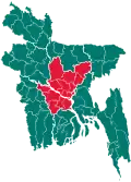
| District | Tangail |
| Area | |
• Total | 193.37 km2 (74.66 sq mi) |
| Population | |
• Total | 270,333 |
| • Density | 1,400/km2 (3,600/sq mi) |
| Time zone | UTC+6 (BST) |
| Postal code | 1990[2] |
| Area code | 09226[3] |
| Website | gopalpur |
Gopalpur (Bengali: গোপালপুর) is an upazila of Tangail District[4] in the Division of Dhaka, Bangladesh.
Geography
Gopalpur is located at 24°33′30″N 89°55′00″E / 24.5583°N 89.9167°E. It has a total area of 193.37 km2.
Demographics
| Year | Pop. (000) | ±% |
|---|---|---|
| 1981 | 205 | — |
| 1991 | 253 | +23.4% |
| 2001 | 274 | +8.3% |
| 2011 | 263 | −4.0% |
| 2022 | 270 | +2.7% |
| Source: Bangladesh Bureau of Statistics[5] | ||
According to the 2011 Census of Bangladesh, Gopalpur Upazila had 63,976 households and a population of 252,331. 54,069 (21.43%) were under 10 years of age. Gopalpur had a literacy rate (age 7 and over) of 45.70%, compared to the national average of 51.8%, and a sex ratio of 1043 females per 1000 males. 50,160 (19.88%) lived in urban areas.[5][7]
Administration
Gopalpur Upazila is divided into Gopalpur Municipality and seven union parishads: Alamnagar, Dhopakandi, Hadira, Hemnagar, Jhawail, Mirzapur, and Nagda Simla. The union parishads are subdivided into 111 mauzas and 158 villages.[5]
Gopalpur Municipality is subdivided into 9 wards and 35 mahallas.[5]
See also
References
- ^ National Report (PDF). Population and Housing Census 2022. Vol. 1. Dhaka: Bangladesh Bureau of Statistics. November 2023. p. 399. ISBN 978-9844752016.
- ^ "Bangladesh Postal Code". Dhaka: Bangladesh Postal Department under the Department of Posts and Telecommunications of the Ministry of Posts, Telecommunications and Information Technology of the People's Republic of Bangladesh. 20 October 2024.
- ^ "Bangladesh Area Code". Stockholm, Sweden: Rebtel.com. 18 October 2024.
- ^ Samaresh Devnath (2012), "Gopalpur Upazila", in Sirajul Islam and Ahmed A. Jamal (ed.), Banglapedia: National Encyclopedia of Bangladesh (Second ed.), Asiatic Society of Bangladesh
- ^ a b c d "Bangladesh Population and Housing Census 2011 Zila Report – Tangail" (PDF). bbs.gov.bd. Bangladesh Bureau of Statistics.
- ^ Population and Housing Census 2022 - District Report: Tangail (PDF). District Series. Dhaka: Bangladesh Bureau of Statistics. June 2024. ISBN 978-984-475-273-3.
- ^ "Community Tables: Tangail district" (PDF). bbs.gov.bd. Bangladesh Bureau of Statistics. 2011.
External links
| Upazilas/thanas | ||
|---|---|---|