Gordonville, Texas
Gordonville, Texas | |
|---|---|
 Gordonville | |
| Coordinates: 33°47′44″N 96°51′10″W / 33.79556°N 96.85278°W | |
| Country | United States |
| State | Texas |
| County | Grayson |
| Named after | Silas M. Gordon |
| Area | |
| 27.77 sq mi (71.9 km2) | |
| • Land | 22.63 sq mi (58.6 km2) |
| • Water | 5.14 sq mi (13.3 km2) |
| • Metro | 979 sq mi (2,536 km2) |
| Population (2010) | |
| 1,714[1] | |
| • Density | 76/sq mi (29/km2) |
| • Metro | 120,877 |
| • Metro density | 130/sq mi (50/km2) |
| Time zone | UTC-6 (Central (CST)) |
| • Summer (DST) | UTC-5 (CDT) |
| ZIP codes | 76245 |
| Area codes | 903, 430 |
Gordonville is an unincorporated community in northwestern Grayson County, Texas, United States.[2]
History
Gordonville is situated on Farm to Market Road 901, and sits on the shore of Lake Texoma. It was part of a sheep ranch until 1872. William Quantrill and his army often visited Gordonville during the American Civil War, and Quantrill named the town after his treasurer, Silas M. Gordon.[3]
References
- ^ Population information
- ^ "Geographic Names Information System". edits.nationalmap.gov. Retrieved July 15, 2024.
- ^ Association, Texas State Historical. "Gordonville, TX". Texas State Historical Association. Retrieved July 15, 2024.
Municipalities and communities of Grayson County, Texas, United States | ||
|---|---|---|
| Cities | 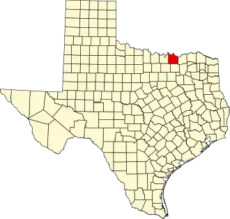 | |
| Towns | ||
| CDPs | ||
| Other communities | ||
| Footnotes | ‡This populated place also has portions in an adjacent county or counties | |