Grafrath
Grafrath | |
|---|---|
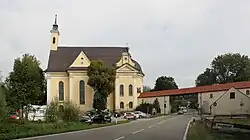 Saint Rasso church | |
 Coat of arms | |
Location of Grafrath within Fürstenfeldbruck district 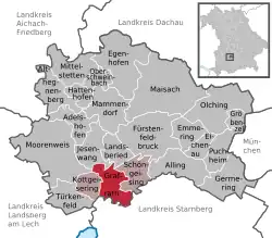 | |
 Grafrath  Grafrath | |
| Coordinates: 48°07′N 11°10′E / 48.117°N 11.167°E | |
| Country | Germany |
| State | Bavaria |
| Admin. region | Oberbayern |
| District | Fürstenfeldbruck |
| Municipal assoc. | |
| Subdivisions | 3 Ortsteile |
| Government | |
| • Mayor (2020–26) | Markus Kennerknecht[1] |
| Area | |
• Total | 14.43 km2 (5.57 sq mi) |
| Elevation | 550 m (1,800 ft) |
| Population (2024-12-31)[2] | |
• Total | 3,885 |
| • Density | 270/km2 (700/sq mi) |
| Time zone | UTC+01:00 (CET) |
| • Summer (DST) | UTC+02:00 (CEST) |
| Postal codes | 82284 |
| Dialling codes | 08144 |
| Vehicle registration | FFB |
| Website | www.grafrath.de |
Grafrath (German pronunciation: [ˈɡʁaːfʁaːt]) is a municipality in the district of Fürstenfeldbruck in Bavaria in Germany. It takes its name from Saint Rasso (Ratho), a count (Graf) who founded a Benedictine abbey in the 10th century, and which existed until 1803.[3][4]
Points of interest
References
- ^ Liste der ersten Bürgermeister/Oberbürgermeister in kreisangehörigen Gemeinden, Bayerisches Landesamt für Statistik, 15 July 2021.
- ^ "Gemeinden, Kreise und Regierungsbezirke in Bayern, Einwohnerzahlen am 31. Dezember 2024; Basis Zensus 2022" [Municipalities, counties, and administrative districts in Bavaria; Based on the 2022 Census] (CSV) (in German). Bayerisches Landesamt für Statistik.
- ^ Rasso (Ratho) von Andechs - Ökumenisches Heiligenlexikon
- ^ Chisholm, Hugh, ed. (1911). . Encyclopædia Britannica. Vol. 12 (11th ed.). Cambridge University Press. p. 316.
External links
![]() Media related to Grafrath at Wikimedia Commons
Media related to Grafrath at Wikimedia Commons
Towns and municipalities in Fürstenfeldbruck district | ||
|---|---|---|