Grove City Airport
Grove City Airport | |||||||||||
|---|---|---|---|---|---|---|---|---|---|---|---|
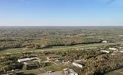 Aerial photograph of the airport taken from the pattern altitude | |||||||||||
| Summary | |||||||||||
| Airport type | Public | ||||||||||
| Owner | Borough of Grove City | ||||||||||
| Location | Grove City, Pennsylvania | ||||||||||
| Elevation AMSL | 1,371 ft / 417.9 m | ||||||||||
| Coordinates | 41°08′45.7″N 080°10′03.9″W / 41.146028°N 80.167750°W | ||||||||||
| Maps | |||||||||||
 | |||||||||||
 29D Location of airport in Pennsylvania  29D 29D (the United States) | |||||||||||
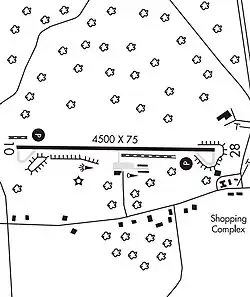
| Runways | |||||||||||
| |||||||||||
Grove City Airport (FAA LID: 29D) is a public airport 3 miles (4.8 km) west of Grove City, in Mercer County, Pennsylvania. When the old one was phased out,[1] the new one was built in 1973.[2]
See also
References
External links
Wikimedia Commons has media related to Grove City Airport.
- "AirNav: 29D - Grove City Airport". airnav.com. Retrieved 2014-08-06.