Guadalupe Victoria, Puebla
Guadalupe Victoria Municipality | |
|---|---|
Municipality | |
 Seal | |
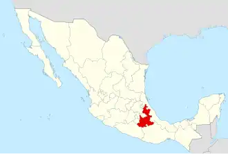
 Guadalupe Victoria Municipality | |
| Coordinates: 19°17′00″N 97°20′00″W / 19.28333°N 97.33333°W | |
| Country | |
| State | Puebla |
| Area | |
• Total | 239.83 km2 (92.60 sq mi) |
| Population (2005)Municipality | |
• Total | 15,041 |
| Time zone | UTC-6 (Central (US Central)) |
| • Summer (DST) | UTC-5 (Central) |
| Website | (in Spanish) |
Guadalupe Victoria Municipality is a municipality in the Mexican state of Puebla. According to the National Statistics Institute (INEGI), it had a population of 15,041 inhabitants in the 2005 census. Its total area is 239.83 km². It is named after Guadalupe Victoria, the first president of Mexico.
Its geographical coordinates are 19° 17′ North, and 97° 20′ West. Its average altitude is 2,440 metres (8,005 ft) above sea level. Its highest elevation is the rhyolitic twin dome volcano Las Derrumbadas (3480 m).
External links