Guttaring
Guttaring | |
|---|---|
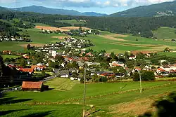 View of Guttaring | |
 Coat of arms | |
 Guttaring Location within Austria | |
| Coordinates: 46°53′N 14°31′E / 46.883°N 14.517°E | |
| Country | Austria |
| State | Carinthia |
| District | Sankt Veit an der Glan |
| Government | |
| • Mayor | Herbert Kuss |
| Area | |
• Total | 54.93 km2 (21.21 sq mi) |
| Elevation | 624 m (2,047 ft) |
| Population (2018-01-01)[2] | |
• Total | 1,470 |
| • Density | 27/km2 (69/sq mi) |
| Time zone | UTC+1 (CET) |
| • Summer (DST) | UTC+2 (CEST) |
| Postal code | 9334 |
| Area code | 04262 |
| Website | www.guttaring.at |
Guttaring (Slovene: Kotarče) is a town in the district of Sankt Veit an der Glan in the Austrian state of Carinthia.
Geography
Guttaring lies between Krappfeld and Görtschitztal and is traversed by the Silberbach.
References
- ^ "Dauersiedlungsraum der Gemeinden Politischen Bezirke und Bundesländer - Gebietsstand 1.1.2018". Statistics Austria. Retrieved 10 March 2019.
- ^ "Einwohnerzahl 1.1.2018 nach Gemeinden mit Status, Gebietsstand 1.1.2018". Statistics Austria. Retrieved 9 March 2019.
Wikimedia Commons has media related to Guttaring.