Höpfingen
Höpfingen | |
|---|---|
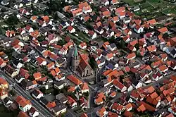 Aerial view of St. Ägidius Church and surrounding area in the Höpfingen subdivision | |
 Coat of arms | |
Location of Höpfingen within Neckar-Odenwald-Kreis district 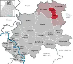 | |
 Höpfingen  Höpfingen | |
| Coordinates: 49°36′5″N 9°25′51″E / 49.60139°N 9.43083°E | |
| Country | Germany |
| State | Baden-Württemberg |
| Admin. region | Karlsruhe |
| District | Neckar-Odenwald-Kreis |
| Subdivisions | 2 |
| Government | |
| • Mayor (2021–29) | Christian Hauck[1] |
| Area | |
• Total | 30.49 km2 (11.77 sq mi) |
| Elevation | 377 m (1,237 ft) |
| Population (2023-12-31)[2] | |
• Total | 3,060 |
| • Density | 100/km2 (260/sq mi) |
| Time zone | UTC+01:00 (CET) |
| • Summer (DST) | UTC+02:00 (CEST) |
| Postal codes | 74746 |
| Dialling codes | 06283 |
| Vehicle registration | MOS, BCH |
| Website | www.hoepfingen.de |
Höpfingen, sometimes spelled Hoepfingen, is a municipality in the district of Neckar-Odenwald-Kreis, in Baden-Württemberg, Germany.
Administration
The municipality consists of two subdivisions:
- Höpfingen
- Waldstetten
Geography
The district lies on the southeastern slope of the Odenwald mountain range. Part is included with the Neckartal-Odenwald Nature Park, one of the largest national parks in Baden-Württemberg.
Höpfingen, in the northern part of the municipality, has forests, fields and meadows. To the south, the town of Waldstetten sits in a valley with several streams running through.[3]
References
- ^ Aktuelle Wahlergebnisse, Staatsanzeiger, accessed 13 September 2021.
- ^ "Bevölkerung nach Nationalität und Geschlecht am 31. Dezember 2023 (Fortschreibung auf Basis des Zensus 2022)" [Population by nationality and sex as of December 31, 2023 (updated based on the 2022 census)] (CSV) (in German). Statistisches Landesamt Baden-Württemberg.
- ^ "Unsere Ortsteile". Archived from the original on 15 August 2022. Retrieved 2 February 2016.
Towns and municipalities in Neckar-Odenwald (district) | ||
|---|---|---|
 | ||