Hüls (Krefeld)
Hüls | |
|---|---|
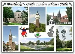 Collage of Hüls | |
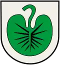 Coat of arms | |
Location of Hüls | |
 Hüls  Hüls | |
| Coordinates: 51°22′20″N 6°30′40″E / 51.37222°N 6.51111°E | |
| Country | Germany |
| State | North Rhine-Westphalia |
| Admin. region | Düsseldorf |
| District | Urban district |
| City | Krefeld |
| Area | |
• Total | 26.08 km2 (10.07 sq mi) |
| Population (2019-12-31)[1] | |
• Total | 16,378 |
| • Density | 630/km2 (1,600/sq mi) |
| Time zone | UTC+01:00 (CET) |
| • Summer (DST) | UTC+02:00 (CEST) |
| Vehicle registration | KR |
Hüls is the most northerly district of Krefeld, North Rhine-Westphalia, Germany. Formerly an independent municipality, Hüls has been part of the city of Krefeld since 1975. It was the site of damask and velvet manufacturing.[2] Including the small district of Hülserberg, it covers 26.08 km2 (10.07 sq mi) and has 16,378 inhabitants (2019).[1]
History
Stone Age and Roman Time
A few flint artifacts from the Neolithic (5500 - 2000 BC) are proof of human activity on the territory of what is now Hüls. A few graves from the Iron Age have been discovered near what is now Botzweg.
References
- ^ a b "Stadtteilatlas - Strukturdaten 2019" (PDF). Stadt Krefeld. Retrieved 27 September 2021.
- ^ Chisholm, Hugh, ed. (1911). . Encyclopædia Britannica. Vol. 13 (11th ed.). Cambridge University Press. p. 871.